IMAGES TAKEN NEAR TO
Darite, LISKEARD, PL14 5JX
Introduction
This page details the photographs taken nearby to PL14 5JX by members of the Geograph project.
The Geograph project started in 2005 with the aim of publishing, organising and preserving representative images for every square kilometre of Great Britain, Ireland and the Isle of Man.

There are currently over 7.5m images from over14,400 individuals and you can help contribute to the project by visiting https://www.geograph.org.uk
Image Map (Loading...)


Getting Data...Please wait
Leaflet Map data © OpenStreetMap
Images are licensed for reuse under creativecommons.org/licenses/by-sa/2.0
Notes
- Clicking on the map will re-center to the selected point.
- The higher the marker number, the further away the image location is from the centre of the postcode.
Image Listing (10 Images Found)
Images are licensed for reuse under creativecommons.org/licenses/by-sa/2.0
Image
Details
Distance
1
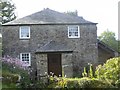
Trenouth Mill
Trenouth Mill, a grade 2 listed building on the road leading to Trenouth Farm.
Image: © Eric Foster
Taken: 19 Aug 2011
0.01 miles
2
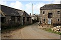
Trenouth Farm
Old farm buildings here at the centre of the farmyard.
Image: © Tony Atkin
Taken: 10 Mar 2007
0.06 miles
3
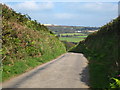
The lane down to Trenouth
On the skyline are the spoil heaps at Gonamena.
Image: © Rod Allday
Taken: 27 Sep 2009
0.22 miles
4
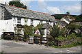
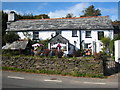
St Cleer: Crows Nest Inn
At Crow's Nest, a hamlet east of Darite, in St Cleer parish. The inn dates from the 17th century and has served as a mine captain's house. It is said to be haunted. With Caradon Hill seen on the skyline
Image: © Martin Bodman
Taken: 31 Aug 2010
0.22 miles
5
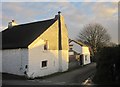
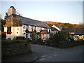
Cottage, Crow's Nest
At the crossroads in the centre of the hamlet; the lane, carrying the Caradon Trail, leads to Trenouth. Tinner's Gate has a cat slide roof (left).
Image: © Derek Harper
Taken: 13 Dec 2014
0.22 miles
7
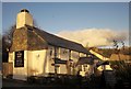
The Crow's Nest public house
In the village of the same name. Customers are making the most of the late September sun in the attractive garden.
Image: © Rod Allday
Taken: 27 Sep 2009
0.23 miles
8
Crow's Nest
The pub is also shown in http://www.geograph.org.uk/search.php?i=53049340 and is listed - see http://list.english-heritage.org.uk/resultsingle.aspx?uid=1140472&searchtype=mapsearch . "House, now inn. Mid C17".
Image: © Derek Harper
Taken: 13 Dec 2014
0.24 miles
9
Which came first - the village or the pub?
Both are called Crow's Nest. I suspect the village was there first, but only by a short margin, it being a mining settlement - those old boys would have had thirsts that needed quenching.
Image: © Richard Law
Taken: 28 Dec 2008
0.24 miles
10
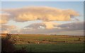
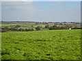
Farmland near Trenouth
The chimney of Trevethy Farm can be seen across the field. It sits in the Seaton valley.
Image: © Derek Harper
Taken: 13 Dec 2014
0.25 miles