IMAGES TAKEN NEAR TO
St. Cleer, LISKEARD, PL14 5EB
Introduction
This page details the photographs taken nearby to PL14 5EB by members of the Geograph project.
The Geograph project started in 2005 with the aim of publishing, organising and preserving representative images for every square kilometre of Great Britain, Ireland and the Isle of Man.

There are currently over 7.5m images from over14,400 individuals and you can help contribute to the project by visiting https://www.geograph.org.uk
Image Map
Images are licensed for reuse under creativecommons.org/licenses/by-sa/2.0
Notes
- Clicking on the map will re-center to the selected point.
- The higher the marker number, the further away the image location is from the centre of the postcode.
Image Listing (4 Images Found)
Images are licensed for reuse under creativecommons.org/licenses/by-sa/2.0
Image
Details
Distance
1
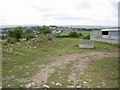
Feeder and barn
Barn isn't marked on the map, but looks fairly new.
Image: © Hugh Venables
Taken: 11 Aug 2006
0.13 miles
2
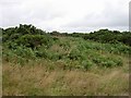
Unnamed open area
Marked as open access, but too small for any useful activity.
Image: © Hugh Venables
Taken: 11 Aug 2006
0.17 miles
3
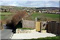
Valley north of St Cleer
To the north of St Cleer village there are several smaller settlements leading up to Caradon Hill (the one with the tall mast on top). These developed in the 19th century to house workers associated with the mines on the southern flank of Caradon Hill.
Image: © Tony Atkin
Taken: 10 Mar 2007
0.23 miles
4
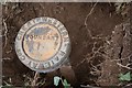
Old Boundary Marker
Railway Boundary Marker on the edge of a play area adjacent to the Memorial Hall on Well Lane. St Cleer parish. In raised lettering GREAT WESTERN RAILWAY Coy (around the outer edge) / BOUNDARY (in the centre).
Milestone Society National ID: CW_CLEER01em
Image: © B Oldham
Taken: 8 Jul 2020
0.23 miles