IMAGES TAKEN NEAR TO
Chapel Row, LISKEARD, PL14 5BN
Introduction
This page details the photographs taken nearby to Chapel Row, PL14 5BN by members of the Geograph project.
The Geograph project started in 2005 with the aim of publishing, organising and preserving representative images for every square kilometre of Great Britain, Ireland and the Isle of Man.

There are currently over 7.5m images from over14,400 individuals and you can help contribute to the project by visiting https://www.geograph.org.uk
Image Map (Loading...)


Getting Data...Please wait
Leaflet Map data © OpenStreetMap
Images are licensed for reuse under creativecommons.org/licenses/by-sa/2.0
Notes
- Clicking on the map will re-center to the selected point.
- The higher the marker number, the further away the image location is from the centre of the postcode.
Image Listing (8 Images Found)
Images are licensed for reuse under creativecommons.org/licenses/by-sa/2.0
Image
Details
Distance
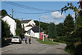
2
Henwood
A similar view to Image of the hamlet and its little green.
Image: © Derek Harper
Taken: 20 Apr 2015
0.04 miles
3
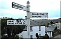
Direction Sign - Signpost in Henwood
Located on a grass island in the centre of Henwood. Linkinhorne parish. 3 arms and pyramid spear finial. See also https://www.geograph.org.uk/photo/956050.
Milestone Society National ID: CW_SX2673
Image: © P McCrickard
Taken: 1 Apr 2018
0.05 miles
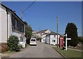
4
Linkinhorne: Henwood
A hamlet in Linkinhorne parish, seen from a point near the old Post Office
Image: © Martin Bodman
Taken: 27 Aug 2010
0.06 miles
5
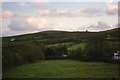
Henwood, looking towards Caradon Hill
The communications mast on Caradon Hill is just visible on the skyline and, to its right, is the silhouette of one of the Phoenix Mine engine houses.
Image: © E Gammie
Taken: 8 Nov 1996
0.07 miles

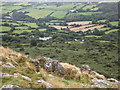
7
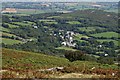
Henwood
Looking down from Stowe Hill to the hamlet of Henwood.
Image: © Tony Atkin
Taken: 11 Aug 2007
0.08 miles
8
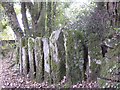
Interesting row of upright stones
On the footpath from Henwood Village to Darley stands this unusual row of upright stones, which form a barrier between the path and the adjacent land. This old green lane has many remains of centuries old buildings, barely visible now having been almost hidden by the natural undergrowth. It must have at one time been a regularly used byway, with evident field enclosures but time,the damp nature of the area and lack of sunlight has resulted in a covering of green moss.
Image: © Eric Foster
Taken: 18 Oct 2009
0.24 miles