IMAGES TAKEN NEAR TO
Pounda, LISKEARD, PL14 4SA
Introduction
This page details the photographs taken nearby to Pounda, PL14 4SA by members of the Geograph project.
The Geograph project started in 2005 with the aim of publishing, organising and preserving representative images for every square kilometre of Great Britain, Ireland and the Isle of Man.

There are currently over 7.5m images from over14,400 individuals and you can help contribute to the project by visiting https://www.geograph.org.uk
Image Map
Images are licensed for reuse under creativecommons.org/licenses/by-sa/2.0
Notes
- Clicking on the map will re-center to the selected point.
- The higher the marker number, the further away the image location is from the centre of the postcode.
Image Listing (16 Images Found)
Images are licensed for reuse under creativecommons.org/licenses/by-sa/2.0
Image
Details
Distance
1
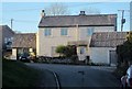
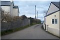
Houses at St Keyne
A pair of semis face down the street from the lane to Penhale.
Image: © Derek Harper
Taken: 4 Feb 2015
0.02 miles
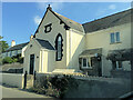
3
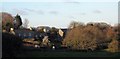
Valley View, St Keyne
Modern housing development in St Keyne village; the church tower can be seen in the background.
Image: © Stephen McKay
Taken: 20 Oct 2009
0.07 miles
4
B3254 at St Keyne
Most of the built-up area of the village is to the right of the B road. In the distance is Image
Image: © Derek Harper
Taken: 4 Feb 2015
0.09 miles
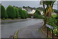
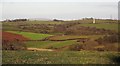
5
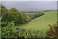
Looe Valley from St Keyne
Looking down into the valley of the East Looe River from the B3254 just north of St Keyne village. Rain clouds are slowly disappearing to the east heralding a slight brightening of the weather following a very dull and wet morning.
Image: © Stephen McKay
Taken: 20 Oct 2009
0.09 miles
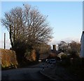
6
Killcrew, St Keyne
East Killcrew, the C18 farmhouse on the left, is described at http://list.historicengland.org.uk/resultsingle.aspx?uid=1140837&searchtype=mapsearch . The B3254 can be seen on this side of the farm.
Image: © Derek Harper
Taken: 4 Feb 2015
0.10 miles
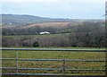
10
Towards the East Looe valley
From the B3254 at St Keyne.
Image: © Derek Harper
Taken: 4 Feb 2015
0.17 miles