IMAGES TAKEN NEAR TO
Broad Park, LISKEARD, PL14 4RH
Introduction
This page details the photographs taken nearby to Broad Park, PL14 4RH by members of the Geograph project.
The Geograph project started in 2005 with the aim of publishing, organising and preserving representative images for every square kilometre of Great Britain, Ireland and the Isle of Man.

There are currently over 7.5m images from over14,400 individuals and you can help contribute to the project by visiting https://www.geograph.org.uk
Image Map (Loading...)


Getting Data...Please wait
Leaflet Map data © OpenStreetMap
Images are licensed for reuse under creativecommons.org/licenses/by-sa/2.0
Notes
- Clicking on the map will re-center to the selected point.
- The higher the marker number, the further away the image location is from the centre of the postcode.
Image Listing (18 Images Found)
Images are licensed for reuse under creativecommons.org/licenses/by-sa/2.0
Image
Details
Distance
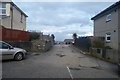
2
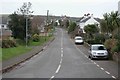
Looking towards the village
This is the road looking towards Liskeard at the entrance to St Keyne.
Image: © roger geach
Taken: 29 Nov 2008
0.04 miles
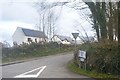
3
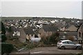
St Keyne village
The newer estates at St Keyne as seen from the road opposite the church.
Image: © roger geach
Taken: 29 Nov 2008
0.05 miles
7
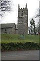
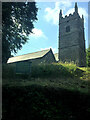
St Keyne Church Tower
Right on the bend is the church at St Keyne.
Image: © roger geach
Taken: 29 Nov 2008
0.07 miles
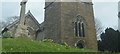
9
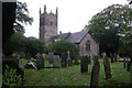
St Keyne Church
This village church, seen here on a very dull day, is largely 15th century although it is believed that this is the site of an earlier building. St Keyne (or Keyn) is said to have been the daughter of a Welsh king who travelled widely and lived for a time in this district of Cornwall.
Image: © Stephen McKay
Taken: 20 Oct 2009
0.08 miles
10
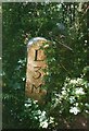
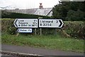
Old Milestone by the B3254 in St Keyne
Launceston pillar by the B3254, in parish of St Keyne (Caradon District), just South of St Keyne's church, round the bend, just beyond the churchyard.
Lost since 1970.
Inscription reads:-
L
3
M
(To Liskeard 3 Miles)
Cornwall & Scilly HER.
HER Number: 176580 https://www.heritagegateway.org.uk/Gateway/Results_Single.aspx?uid=MCO52400&resourceID=1020
Milestone Society National ID: CW_LKLO03
Image: © Milestone Society
Taken: Unknown
0.09 miles