IMAGES TAKEN NEAR TO
St. Keyne, LISKEARD, PL14 4QL
Introduction
This page details the photographs taken nearby to PL14 4QL by members of the Geograph project.
The Geograph project started in 2005 with the aim of publishing, organising and preserving representative images for every square kilometre of Great Britain, Ireland and the Isle of Man.

There are currently over 7.5m images from over14,400 individuals and you can help contribute to the project by visiting https://www.geograph.org.uk
Image Map (Loading...)


Getting Data...Please wait
Leaflet Map data © OpenStreetMap
Images are licensed for reuse under creativecommons.org/licenses/by-sa/2.0
Notes
- Clicking on the map will re-center to the selected point.
- The higher the marker number, the further away the image location is from the centre of the postcode.
Image Listing (18 Images Found)
Images are licensed for reuse under creativecommons.org/licenses/by-sa/2.0
Image
Details
Distance
3
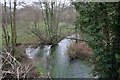
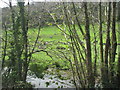
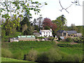
The East Looe river looking downstream
The view off the narrow bridge looking down stream from the b3254 road to St Keyne.
Image: © roger geach
Taken: 29 Nov 2008
0.11 miles
5
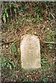
Old Milestone by the B3254, south of Trussel Bridge
Carved stone post by the B3254, in parish of ST KEYNE (CARADON District), near Trussel Bridge, against high bank at edge of road, on steep hill, on bend, on West side of road. Launceston pillar, erected by the Liskeard turnpike trust in the 19th century.
Inscription reads:-
: L / H :
(Should be II (2), not H)
Carved bench mark and rivet on top.
Milestone Society National ID: CW_LKLO02.
Image: © Ian Thompson
Taken: 1 Feb 2006
0.11 miles
6
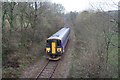
Looe Valley train
Seen at Trussel bridge this is the Looe to Liskeard train heading towards Coombe Junction.
Image: © roger geach
Taken: 29 Nov 2008
0.12 miles
7
Old Milestone by the B3254, south of Trussel Bridge
Carved stone post by the B3254, in parish of ST KEYNE (CARADON District), near Trussel Bridge, against high bank at edge of road on steep hill on bend, on West side of road. Launceston pillar, erected by the Liskeard turnpike trust in the 19th century.
Inscription reads:-
L
H
(Should be II, not H)
Carved benchmark and rivet on top.
Cornwall & Scilly HER.
HER Number: 178419 https://www.heritagegateway.org.uk/Gateway/Results_Single.aspx?uid=MCO54195&resourceID=1020
Milestone Society National ID: CW_LKLO02
Image: © Rosy Hanns
Taken: 17 Apr 2019
0.12 miles
8
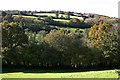
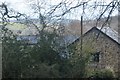
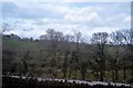
Autumnal Hillside
Looking up the western side of Looe Valley near Trussel Farm.
Image: © Tony Atkin
Taken: 29 Oct 2006
0.12 miles