IMAGES TAKEN NEAR TO
Valley View, LISKEARD, PL14 4NX
Introduction
This page details the photographs taken nearby to Valley View, PL14 4NX by members of the Geograph project.
The Geograph project started in 2005 with the aim of publishing, organising and preserving representative images for every square kilometre of Great Britain, Ireland and the Isle of Man.

There are currently over 7.5m images from over14,400 individuals and you can help contribute to the project by visiting https://www.geograph.org.uk
Image Map
Images are licensed for reuse under creativecommons.org/licenses/by-sa/2.0
Notes
- Clicking on the map will re-center to the selected point.
- The higher the marker number, the further away the image location is from the centre of the postcode.
Image Listing (27 Images Found)
Images are licensed for reuse under creativecommons.org/licenses/by-sa/2.0
Image
Details
Distance
1
Old Mill, Trevelmond
On the lane between Trevelmond and St Pinnock, as it crosses the deep little valley of a tributary of the West Looe.
Image: © Derek Harper
Taken: 31 Mar 2016
0.03 miles
2
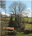
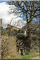
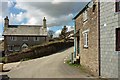
Trees at Trevelmond
The sheds appear in Image The houses are on an upper lane which leads eventually to Liskeard station.
Image: © Derek Harper
Taken: 31 Mar 2016
0.09 miles
4
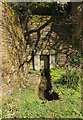
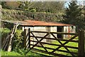
Well, Trevelmond
At the head of a steep valley below the hamlet, and also shown in
Image
Image: © Derek Harper
Taken: 31 Mar 2016
0.10 miles
5
Well, Trevelmond
Placing Image] in more context, with a lane skirting the centre of the hamlet, and a house up above.
Image: © Derek Harper
Taken: 31 Mar 2016
0.10 miles
6
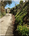
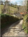
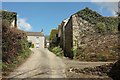
Lane to Trevelmond
A steep climb from the junction by the well (Image]).
Image: © Derek Harper
Taken: 31 Mar 2016
0.13 miles
7
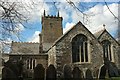
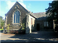
Church of St Pynnochus, St Pinnock
Like Image, showing the east end of the church, but from a different angle. The grade I listed church is also shown in http://www.geograph.org.uk/search.php?i=62082044 and is described at https://www.historicengland.org.uk/listing/the-list/list-entry/1140308 .
Image: © Derek Harper
Taken: 31 Mar 2016
0.13 miles
8
Trevelmond Farm
The farmhouse faces the camera; on the right are cottages. The lane leads towards Doublebois.
Image: © Derek Harper
Taken: 31 Mar 2016
0.14 miles
9
Trevelmond
Reaching the top of the hill shown in Image
Image: © Derek Harper
Taken: 31 Mar 2016
0.14 miles