IMAGES TAKEN NEAR TO
Wherry Way, LISKEARD, PL14 4NS
Introduction
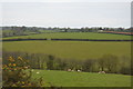
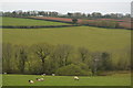
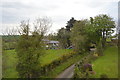
This page details the photographs taken nearby to Wherry Way, PL14 4NS by members of the Geograph project.
The Geograph project started in 2005 with the aim of publishing, organising and preserving representative images for every square kilometre of Great Britain, Ireland and the Isle of Man.

There are currently over 7.5m images from over14,400 individuals and you can help contribute to the project by visiting https://www.geograph.org.uk
Image Map (12 Images)


Getting Data...Please wait
Leaflet Map data © OpenStreetMap
Images are licensed for reuse under creativecommons.org/licenses/by-sa/2.0
Notes
- Clicking on the map will re-center to the selected point.
- The higher the marker number, the further away the image location is from the centre of the postcode.
Image Listing (12 Images Found)
Images are licensed for reuse under creativecommons.org/licenses/by-sa/2.0
Image
Details
Distance
7
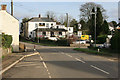
The Highwayman Pub
Dobwalls now bypassed and much quieter these days.
Image: © roger geach
Taken: 25 Nov 2011
0.22 miles
8
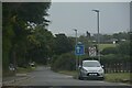
Dobwalls : Road
A road heads out from Dobwalls.
Image: © Lewis Clarke
Taken: 26 Sep 2022
0.23 miles
9
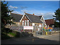
Dobwalls Community Primary School
According to the plaque on the front of the original building, it was constructed by Cornwall County Council in 1906.
Image: © Rod Allday
Taken: 18 Sep 2010
0.23 miles