IMAGES TAKEN NEAR TO
East Taphouse, LISKEARD, PL14 4NH
Introduction
This page details the photographs taken nearby to PL14 4NH by members of the Geograph project.
The Geograph project started in 2005 with the aim of publishing, organising and preserving representative images for every square kilometre of Great Britain, Ireland and the Isle of Man.

There are currently over 7.5m images from over14,400 individuals and you can help contribute to the project by visiting https://www.geograph.org.uk
Image Map
Images are licensed for reuse under creativecommons.org/licenses/by-sa/2.0
Notes
- Clicking on the map will re-center to the selected point.
- The higher the marker number, the further away the image location is from the centre of the postcode.
Image Listing (8 Images Found)
Images are licensed for reuse under creativecommons.org/licenses/by-sa/2.0
Image
Details
Distance
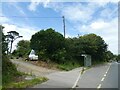
1
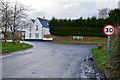
The Herodsfoot road at its junction with the A390
Image: © Roger A Smith
Taken: 11 Feb 2014
0.02 miles
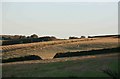
4
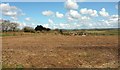
Field near East Taphouse
A view towards Redpost from close to East Taphouse Farm. The A390 is behind the bank, doubtless a Cornish hedge, on the left.
Image: © Derek Harper
Taken: 31 Mar 2016
0.09 miles
6
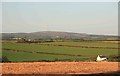
Caradon Hill
Rural East Cornwall as seen from nr Taphouse looking towards Caradon Hill and the local landmark with the TV Transmitter on high.
Image: © roger geach
Taken: 8 Oct 2009
0.16 miles
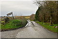
8
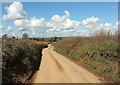
Lane to East Taphouse
Running between Cornish hedges. There's a wind turbine tucked away left of the telegraph pole.
Image: © Derek Harper
Taken: 31 Mar 2016
0.24 miles