IMAGES TAKEN NEAR TO
East Taphouse, LISKEARD, PL14 4NG
Introduction
This page details the photographs taken nearby to PL14 4NG by members of the Geograph project.
The Geograph project started in 2005 with the aim of publishing, organising and preserving representative images for every square kilometre of Great Britain, Ireland and the Isle of Man.

There are currently over 7.5m images from over14,400 individuals and you can help contribute to the project by visiting https://www.geograph.org.uk
Image Map (Loading...)


Getting Data...Please wait
Leaflet Map data © OpenStreetMap
Images are licensed for reuse under creativecommons.org/licenses/by-sa/2.0
Notes
- Clicking on the map will re-center to the selected point.
- The higher the marker number, the further away the image location is from the centre of the postcode.
Image Listing (2 Images Found)
Images are licensed for reuse under creativecommons.org/licenses/by-sa/2.0
Image
Details
Distance
1
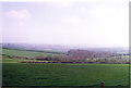
Dobwalls.
Looking in a generally southerly direction from the Park and showing the Liskeard Railway Viaduct in the disrance.
Image: © Ron Hann
Taken: Unknown
0.20 miles
2
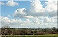
Countryside near Treburgie
From the A390 opposite the junction seen in Image], with a distant glimpse of Liskeard. Stately clouds, but it didn't rain.
Image: © Derek Harper
Taken: 31 Mar 2016
0.21 miles