IMAGES TAKEN NEAR TO
Little Dean, LISKEARD, PL14 4JL
Introduction
This page details the photographs taken nearby to Little Dean, PL14 4JL by members of the Geograph project.
The Geograph project started in 2005 with the aim of publishing, organising and preserving representative images for every square kilometre of Great Britain, Ireland and the Isle of Man.

There are currently over 7.5m images from over14,400 individuals and you can help contribute to the project by visiting https://www.geograph.org.uk
Image Map
Images are licensed for reuse under creativecommons.org/licenses/by-sa/2.0
Notes
- Clicking on the map will re-center to the selected point.
- The higher the marker number, the further away the image location is from the centre of the postcode.
Image Listing (10 Images Found)
Images are licensed for reuse under creativecommons.org/licenses/by-sa/2.0
Image
Details
Distance
2
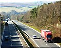
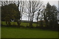
Liskeard, View to West on A38
Dual carriageways into Cornwall have reduced the travelling time. Here a driver can streak past Liskeard on the route to the sun.
Image: © Tom Jolliffe
Taken: 7 Mar 2011
0.13 miles
6
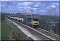
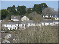
1022 1100 pz - pd near Liskeard station
Image: © roger geach
Taken: 31 Jul 1975
0.21 miles