IMAGES TAKEN NEAR TO
Grove Drive, LISKEARD, PL14 4JH
Introduction
This page details the photographs taken nearby to Grove Drive, PL14 4JH by members of the Geograph project.
The Geograph project started in 2005 with the aim of publishing, organising and preserving representative images for every square kilometre of Great Britain, Ireland and the Isle of Man.

There are currently over 7.5m images from over14,400 individuals and you can help contribute to the project by visiting https://www.geograph.org.uk
Image Map
Images are licensed for reuse under creativecommons.org/licenses/by-sa/2.0
Notes
- Clicking on the map will re-center to the selected point.
- The higher the marker number, the further away the image location is from the centre of the postcode.
Image Listing (23 Images Found)
Images are licensed for reuse under creativecommons.org/licenses/by-sa/2.0
Image
Details
Distance
1
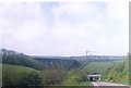
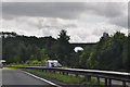
The Descent to Moorswater
Liskeard railway viaduct on the line to Penzance.
Leaving Liskeard on the B3254, the road goes underneath the A38 before joining it.
Image: © Ron Hann
Taken: Unknown
0.10 miles
3
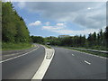
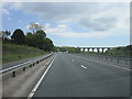
Cornwall : The A38
Looking along the A38 as it heads through Cornwall.
Image: © Lewis Clarke
Taken: 17 Jul 2015
0.11 miles
5
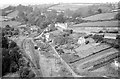
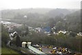
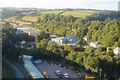
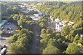
The view from Moorswater Viaduct ? 1964
Looking down on the small village of that name.
The railway is the former Liskeard and Caradon Railway, formed initially to bring minerals and granite down to the coast for shipment, at its junction with the Liskeard and Looe Railway, itself a replacement for a canal. The railways became a single operation from 1878. Only as late as 1901 was it connected to the Great Western Railway main line, the GWR taking it over from 1909. Left of centre is the former locomotive shed (of the Liskeard & Looe Railway) with its twin arched openings. Among other work it would have looked after the locomotives operating the Liskeard to Looe branch, but by the time of this view the service had been dieselised.
the prominent white cottage, can be seen one of the large limekilns that also characterised the area. This still survives and is Listed Grade II. A more recent view from roughly the same point can be seen here https://www.geograph.org.uk/photo/2517459 .
A major change to the landscape has been the upgrading of the A38 into an express dual carriageway.
Image: © Alan Murray-Rust
Taken: Unknown
0.15 miles
8
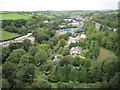
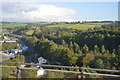
View from a Plymouth-Penzance train - Moorswater
Image: © Nigel Thompson
Taken: 15 Sep 2016
0.19 miles