IMAGES TAKEN NEAR TO
Liggars Drive, LISKEARD, PL14 4FJ
Introduction
This page details the photographs taken nearby to Liggars Drive, PL14 4FJ by members of the Geograph project.
The Geograph project started in 2005 with the aim of publishing, organising and preserving representative images for every square kilometre of Great Britain, Ireland and the Isle of Man.

There are currently over 7.5m images from over14,400 individuals and you can help contribute to the project by visiting https://www.geograph.org.uk
Image Map (Loading...)


Getting Data...Please wait
Leaflet Map data © OpenStreetMap
Images are licensed for reuse under creativecommons.org/licenses/by-sa/2.0
Notes
- Clicking on the map will re-center to the selected point.
- The higher the marker number, the further away the image location is from the centre of the postcode.
Image Listing (17 Images Found)
Images are licensed for reuse under creativecommons.org/licenses/by-sa/2.0
Image
Details
Distance
1
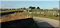
Dobwalls Football Club
The ground is on the south side of the village by the road to Duloe, seen here from the railway bridge from which Image] was taken.
Image: © Derek Harper
Taken: 20 Jan 2016
0.10 miles
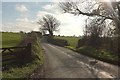
2
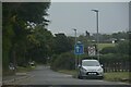
Dobwalls : Road
A road heads out from Dobwalls.
Image: © Lewis Clarke
Taken: 26 Sep 2022
0.15 miles
3
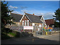
Dobwalls Community Primary School
According to the plaque on the front of the original building, it was constructed by Cornwall County Council in 1906.
Image: © Rod Allday
Taken: 18 Sep 2010
0.15 miles
4
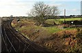
Main line near Dobwalls
From a bridge carrying the road from Duloe. Some of Dobwalls is over on the right.
Image: © Derek Harper
Taken: 20 Jan 2016
0.15 miles

6
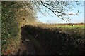
Green lane near Dobwalls
The other end of the green lane shown in Image], looking no less muddy but much more charming now the sun has emerged.
Image: © Derek Harper
Taken: 20 Jan 2016
0.17 miles
7
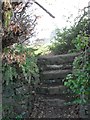
Dobwalls
Stone steps leading to a footpath on the edge of the village.
Image: © Burgess Von Thunen
Taken: 29 Feb 2012
0.17 miles
8
Road to Duloe
Seen from the same spot as Image], looking to the right straight into the sun.
Image: © Derek Harper
Taken: 20 Jan 2016
0.19 miles
9
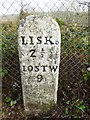
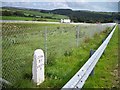
Old Milestone by the former A38, east of Dobwalls
Carved stone post by the UC road (was A38), in parish of DOBWALLS AND TREWIDLAND (CARADON District), East of Dobwalls, on the verge behind Armco barrier, on North side of road. Gravestone erected by the Liskeard turnpike trust in the 18th century.
Inscription reads:-
LISKD 2½
LOSTW
9
Grade II listed.
List Entry Number: 1136526 https://historicengland.org.uk/listing/the-list/list-entry/1136526
Milestone Society National ID: CW_LSLK09.
Image: © Rosy Hanns
Taken: 5 Apr 2019
0.20 miles
10
Old Milestone by the former A38, east of Dobwalls
Carved stone post by the UC road (was A38), in parish of DOBWALLS AND TREWIDLAND (CARADON District), East of Dobwalls, on the verge behind Armco barrier, on North side of road. Gravestone erected by the Liskeard turnpike trust in the 18th century.
Inscription reads:-
LISKD
2½
LOSTW
9
Grade II Listed. List Entry Number: 1136526
https://historicengland.org.uk/listing/the-list/list-entry/1136526
Milestone Society National ID: CW_LSLK09.
Image: © Ian Thompson
Taken: 1 Nov 1998
0.20 miles