IMAGES TAKEN NEAR TO
Heathlands Industrial Estate, LISKEARD, PL14 4DH
Introduction
This page details the photographs taken nearby to Heathlands Industrial Estate, PL14 4DH by members of the Geograph project.
The Geograph project started in 2005 with the aim of publishing, organising and preserving representative images for every square kilometre of Great Britain, Ireland and the Isle of Man.

There are currently over 7.5m images from over14,400 individuals and you can help contribute to the project by visiting https://www.geograph.org.uk
Image Map
Images are licensed for reuse under creativecommons.org/licenses/by-sa/2.0
Notes
- Clicking on the map will re-center to the selected point.
- The higher the marker number, the further away the image location is from the centre of the postcode.
Image Listing (45 Images Found)
Images are licensed for reuse under creativecommons.org/licenses/by-sa/2.0
Image
Details
Distance
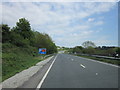
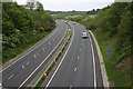
3
Liskeard, View to east along A38
Long shadows stretch across the A38 on a chilly but sunny March day. There is little traffic on the road. Walking from the station, the dual carriageway comes as a surprise.
Image: © Tom Jolliffe
Taken: 7 Mar 2011
0.10 miles

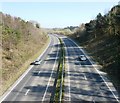
7
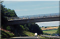
The A38
Traffic on the overbridge heading to Liskeard.
Image: © Robert Ashby
Taken: 8 Aug 2015
0.13 miles
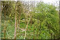
8
Cones on the Liskeard Bypass
Taken from Station Road as it bridges this relatively new cutting.
Image: © Tony Atkin
Taken: 13 May 2006
0.14 miles
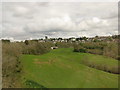
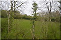
10
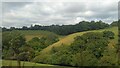
Fields near Liskeard
Some fields near Liskeard, Cornwall.
Image: © Sebastian Doe
Taken: 1 Aug 2019
0.16 miles