IMAGES TAKEN NEAR TO
Pound Park, LISKEARD, PL14 3SB
Introduction
This page details the photographs taken nearby to Pound Park, PL14 3SB by members of the Geograph project.
The Geograph project started in 2005 with the aim of publishing, organising and preserving representative images for every square kilometre of Great Britain, Ireland and the Isle of Man.

There are currently over 7.5m images from over14,400 individuals and you can help contribute to the project by visiting https://www.geograph.org.uk
Image Map
Images are licensed for reuse under creativecommons.org/licenses/by-sa/2.0
Notes
- Clicking on the map will re-center to the selected point.
- The higher the marker number, the further away the image location is from the centre of the postcode.
Image Listing (29 Images Found)
Images are licensed for reuse under creativecommons.org/licenses/by-sa/2.0
Image
Details
Distance
1

Menheniot Parish Institute
I am afraid that I have no other information about this building apart from its name.
Image: © Tony Atkin
Taken: 13 May 2006
0.02 miles
2
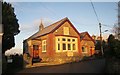
Jago Institute, Menheniot
More information is available than when Image was taken. There's a useful village information board featuring the historic buildings of Menheniot, which helped guide me to a website explaining that "the Edward Jago institute is a billiards and snooker room, left to the men of the village in perpetuity in memory of Edward Jago by his family" . It still operates as such http://www.menheniotparish.org.uk/groups-activities/jago-institute/. The building dates from 1911, as confirmed by the plaque in the gable. Behind it is the cemetery.
Image: © Derek Harper
Taken: 13 Dec 2014
0.02 miles
3
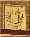
Plaque, Jago Institute, Menheniot
On the building shown in Image and Image], and giving the date 1911. The family arms are shown and described at http://www.mocavo.co.uk/Armorial-Families-a-Directory-of-Gentlemen-of-Coat-Armour-1905-Volume-5/980015/821 and feature choughs, a cormorant and a wolf. The family motto "sermoni consona facta" translates as "deeds answering to words".
Image: © Derek Harper
Taken: 13 Dec 2014
0.02 miles
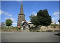
6
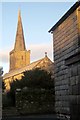
Church of St Lalluwy, Menheniot
With a slate-hung facade of part of Poads Trust Almshouses http://list.english-heritage.org.uk/resultsingle.aspx?uid=1140030&searchtype=mapsearch in the foreground. The church is also shown in http://www.geograph.org.uk/search.php?i=52926368 and described at http://list.english-heritage.org.uk/resultsingle.aspx?uid=1329431&searchtype=mapsearch . In shadow are a part of gate piers and part of the churchyard boundary wall http://list.english-heritage.org.uk/resultsingle.aspx?uid=1136816&searchtype=mapsearch .
Image: © Derek Harper
Taken: 13 Dec 2014
0.03 miles
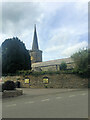
7
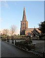
Church of St Lalluwy, Menheniot
Also shown in http://www.geograph.org.uk/search.php?i=52926368 . The church is grade I listed and described at http://list.english-heritage.org.uk/resultsingle.aspx?uid=1329431&searchtype=mapsearch . "In 1965 the dedication reverted from Antoninus to Lalluwy". The lychgate is jointly listed with the boundary wall, drinking fountain, and three pairs of gatepiers http://list.english-heritage.org.uk/resultsingle.aspx?uid=1136816&searchtype=mapsearch .
Image: © Derek Harper
Taken: 13 Dec 2014
0.03 miles
9
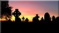
September dusk; Menheniot cemetery
It's gone 8pm in early September.
Image: © Jonathan Billinger
Taken: 6 Sep 2012
0.03 miles
10

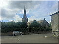
Menheniot Church
This parish church has a fine peal of bells which was clearly heard as I approached the village during bell-ringing practice.
Image: © Tony Atkin
Taken: 13 May 2006
0.03 miles