IMAGES TAKEN NEAR TO
Menheniot, LISKEARD, PL14 3QU
Introduction
This page details the photographs taken nearby to PL14 3QU by members of the Geograph project.
The Geograph project started in 2005 with the aim of publishing, organising and preserving representative images for every square kilometre of Great Britain, Ireland and the Isle of Man.

There are currently over 7.5m images from over14,400 individuals and you can help contribute to the project by visiting https://www.geograph.org.uk
Image Map (7 Images)


Getting Data...Please wait
Leaflet Map data © OpenStreetMap
Images are licensed for reuse under creativecommons.org/licenses/by-sa/2.0
Notes
- Clicking on the map will re-center to the selected point.
- The higher the marker number, the further away the image location is from the centre of the postcode.
Image Listing (7 Images Found)
Images are licensed for reuse under creativecommons.org/licenses/by-sa/2.0
Image
Details
Distance
1

Footpath to Bodway
Heading south-east from the lane from Menheniot.
Image: © Jonathan Billinger
Taken: 13 May 2010
0.09 miles
2
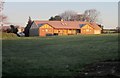
Cricket pavilion, Menheniot
On the Fourgates Cricket Ground, seen from a bend in the lane to Courtney's Mill.
Image: © Derek Harper
Taken: 13 Dec 2014
0.16 miles
3
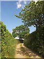
Lane near Bodway
A tiny lane from Courtney's Mill, approaching the farm at Bodway between tall hedgebanks.
Image: © Derek Harper
Taken: 14 Jun 2014
0.18 miles
5

Lane from Bodway
Heading downhill towards Courtney's Mill.
Image: © Jonathan Billinger
Taken: 13 May 2010
0.24 miles
6
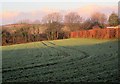
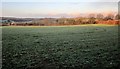
Frosty field, Menheniot
Early in the morning. This is a detail of Image
Image: © Derek Harper
Taken: 13 Dec 2014
0.24 miles
7
Field, Menheniot
A frosty field in early morning sunlight, seen from a bend in the lane to Courtney's Mill. On the left can be seen the line of chimneys on the terrace at Pool Hall.
Image: © Derek Harper
Taken: 13 Dec 2014
0.24 miles