IMAGES TAKEN NEAR TO
Horningtops, LISKEARD, PL14 3QA
Introduction
This page details the photographs taken nearby to PL14 3QA by members of the Geograph project.
The Geograph project started in 2005 with the aim of publishing, organising and preserving representative images for every square kilometre of Great Britain, Ireland and the Isle of Man.

There are currently over 7.5m images from over14,400 individuals and you can help contribute to the project by visiting https://www.geograph.org.uk
Image Map (Loading...)


Getting Data...Please wait
Leaflet Map data © OpenStreetMap
Images are licensed for reuse under creativecommons.org/licenses/by-sa/2.0
Notes
- Clicking on the map will re-center to the selected point.
- The higher the marker number, the further away the image location is from the centre of the postcode.
Image Listing (7 Images Found)
Images are licensed for reuse under creativecommons.org/licenses/by-sa/2.0
Image
Details
Distance
1
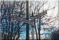
Direction Sign - Signpost by the B3252, Horningtops
Cone finial - Plain Cone, rectangular by the B3252, in parish of Menheniot (Caradon District), Horningtops, on bank.
Surveyed
Milestone Society National ID: CW_SX2760
Image: © Milestone Society
Taken: Unknown
0.02 miles
2

Telephone box, Horningtops
By the B3252 as it approaches the hamlet. The diversion sign indicates that traffic heading for Lean Quarry landfill should go straight on here.
Image: © Derek Harper
Taken: 10 Sep 2015
0.09 miles
3
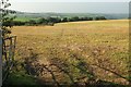
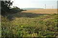
Field west of Horningtops
On the other side of the lane from Image The vegetation on the left is either side of a stream which rises in the field and eventually join the East Looe River.
Image: © Derek Harper
Taken: 10 Sep 2015
0.19 miles
4
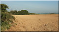
Field west of Horningtops
A hilltop field by the lane to Lean Hill House.
Image: © Derek Harper
Taken: 10 Sep 2015
0.19 miles
5
View across muddy field towards 'Horningtops'
The image subject is within grid square SX2760 and I was too when I took it today in the rain. The main geographical features within the square are predominantly agricultural - as are most squares round these parts. The village on the hill is Horningtops.
Image: © BB
Taken: 19 Feb 2007
0.21 miles
6
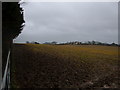
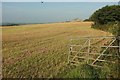
Field south of Horningtops
The B3252 runs behind the hedge on the left.
Image: © Derek Harper
Taken: 10 Sep 2015
0.22 miles
7
Field west of Horningtops
Looking to the right from the same spot as Image The barn is near Lean Hill Cottage. That's a pigeon, I believe.
Image: © Derek Harper
Taken: 10 Sep 2015
0.23 miles