IMAGES TAKEN NEAR TO
Horningtops, LISKEARD, PL14 3PU
Introduction
This page details the photographs taken nearby to PL14 3PU by members of the Geograph project.
The Geograph project started in 2005 with the aim of publishing, organising and preserving representative images for every square kilometre of Great Britain, Ireland and the Isle of Man.

There are currently over 7.5m images from over14,400 individuals and you can help contribute to the project by visiting https://www.geograph.org.uk
Image Map (Loading...)


Getting Data...Please wait
Leaflet Map data © OpenStreetMap
Images are licensed for reuse under creativecommons.org/licenses/by-sa/2.0
Notes
- Clicking on the map will re-center to the selected point.
- The higher the marker number, the further away the image location is from the centre of the postcode.
Image Listing (32 Images Found)
Images are licensed for reuse under creativecommons.org/licenses/by-sa/2.0
Image
Details
Distance
1
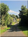
Roundhouse
Hmm, I've seen rounder. A wider version of the scene in Image, which says that the building dates from 1894. The 1882 1:2500 map appears to show a rounder structure here, a lodge, so perhaps this inherited the name if not the shape. It may have been the lower lodge for Coldrenick House, since an 1808 advertisement for the house mentions that its lodge "adjoins the turnpike road from {Torpoint} to Liskeard" http://newspaperarchive.com/uk/middlesex/london/london-star/1808/02-27/ .
This view looks from the A38 along its former course, with the parapets of Roundhouse Bridge where it crosses the River Seaton. The 1882 map shows this as the course of the main road, and names the bridge as "Pucklepit Bridge", while a 1907 map has "Roundhouse Bridge". So it's possible that the bridge changed its name about the time the house changed shape, perhaps to reflect what had been there before.
Image: © Derek Harper
Taken: 10 Sep 2014
0.00 miles
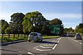
2
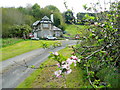
Springtime at the Roundhouse Bridge
The house, dated 1894, is on a loop off the busy A38 between Liskeard and Saltash in the Seaton valley.
Image: © Jonathan Billinger
Taken: 13 May 2010
0.02 miles
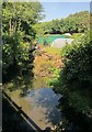
3
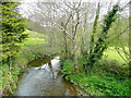
River Seaton
Looking upstream from Roundhouse Bridge.
Image: © Jonathan Billinger
Taken: 13 May 2010
0.05 miles
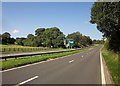
4
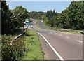
A38 crossing the Seaton valley
A wider view of the scene in Image
Image: © Derek Harper
Taken: 10 Sep 2014
0.05 miles
6
River Seaton
Looking upstream from the A38. Image shows the view downstream, though the equivalent parapet is 40 metres away across a dual carriageway.
Image: © Derek Harper
Taken: 10 Sep 2014
0.05 miles
7
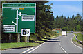
The A38
Did Doddy lose his tickling stick?
Image: © Robert Ashby
Taken: 8 Aug 2015
0.06 miles
8
A38 crossing the Seaton valley
From a little west of the bridge carrying the A38 over the river, with the turn to the Roundhouse shown in Image] a few metres ahead on the right, and a sign giving notice of the Menheniot Turn up the hill.
Image: © Derek Harper
Taken: 10 Sep 2014
0.07 miles
9
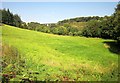
Meadow near Roundhouse Bridge
From beside the A38 in the Seaton valley, looking across the line of vision in Image], with the Coldrenick Viaduct (see Image]) in the background. To its left, just about visible at larger sizes through the conifers, are houses at Lower Clicker.
Image: © Derek Harper
Taken: 10 Sep 2014
0.08 miles
10
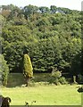
Pond by the River Seaton
A view from the A38. The river curves around the far side of this pond; behind is West Wood.
Image: © Derek Harper
Taken: 10 Sep 2014
0.08 miles