IMAGES TAKEN NEAR TO
St. Ive, LISKEARD, PL14 3NA
Introduction
This page details the photographs taken nearby to PL14 3NA by members of the Geograph project.
The Geograph project started in 2005 with the aim of publishing, organising and preserving representative images for every square kilometre of Great Britain, Ireland and the Isle of Man.

There are currently over 7.5m images from over14,400 individuals and you can help contribute to the project by visiting https://www.geograph.org.uk
Image Map (Loading...)


Getting Data...Please wait
Leaflet Map data © OpenStreetMap
Images are licensed for reuse under creativecommons.org/licenses/by-sa/2.0
Notes
- Clicking on the map will re-center to the selected point.
- The higher the marker number, the further away the image location is from the centre of the postcode.
Image Listing (5 Images Found)
Images are licensed for reuse under creativecommons.org/licenses/by-sa/2.0
Image
Details
Distance
1
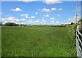
Field near St Ive Cross
The view from the gates on the left of Image
Image: © Derek Harper
Taken: 14 May 2014
0.10 miles
2
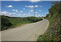
Road to St Ive Cross
From the same place as Image], looking towards the village. The red object is a piece of machinery.
Image: © Derek Harper
Taken: 14 May 2014
0.12 miles
3
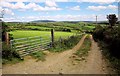
Farm track near St Ive Cross
From the lane south of St Ive Cross.
Image: © Derek Harper
Taken: 14 May 2014
0.15 miles
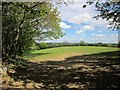
4

Field, Woodcock's Eye
With the lane to St Ive Cross on the left. This is from the start of the route with public access that leads to Sleeve.
Image: © Derek Harper
Taken: 14 May 2014
0.21 miles
5
Field near St Ive Cross
This field by West Trevallack farm is seen from a gateway at the edge of the built-up area of St Ive Cross. Behind the trees on the left is the lane to Thornton.
Image: © Derek Harper
Taken: 14 May 2014
0.22 miles