IMAGES TAKEN NEAR TO
St. Ive, LISKEARD, PL14 3LZ
Introduction
This page details the photographs taken nearby to PL14 3LZ by members of the Geograph project.
The Geograph project started in 2005 with the aim of publishing, organising and preserving representative images for every square kilometre of Great Britain, Ireland and the Isle of Man.

There are currently over 7.5m images from over14,400 individuals and you can help contribute to the project by visiting https://www.geograph.org.uk
Image Map (Loading...)


Getting Data...Please wait
Leaflet Map data © OpenStreetMap
Images are licensed for reuse under creativecommons.org/licenses/by-sa/2.0
Notes
- Clicking on the map will re-center to the selected point.
- The higher the marker number, the further away the image location is from the centre of the postcode.
Image Listing (7 Images Found)
Images are licensed for reuse under creativecommons.org/licenses/by-sa/2.0
Image
Details
Distance
1
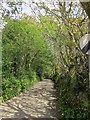
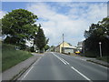
Lane to Thornton
The lane from St Ive Cross leaves the housing and plunges down through trees.
Image: © Derek Harper
Taken: 14 May 2014
0.10 miles
2
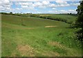
Valley near St Ive Cross
On the other side of the lane from Image
Image: © Derek Harper
Taken: 14 May 2014
0.10 miles
3
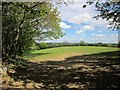
Field near St Ive Cross
This field by West Trevallack farm is seen from a gateway at the edge of the built-up area of St Ive Cross. Behind the trees on the left is the lane to Thornton.
Image: © Derek Harper
Taken: 14 May 2014
0.10 miles
6
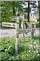
Old Direction Sign - Signpost by the A390, near St Ive Cross
Raised finial - 'G' type; by the A390, in parish of St Ive (Caradon District), at turn South to St Ive Cross, at apex of Y-junction.
Cornwall and Scilly HER.
HER Number: MCO56959 https://www.heritagegateway.org.uk/Gateway/Results_Single.aspx?uid=MCO56959&resourceID=1020
To be surveyed
Milestone Society National ID: CW_SX3167
Image: © Milestone Society
Taken: Unknown
0.23 miles
7
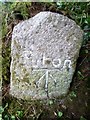
Old Boundary Marker
Turnpike Horse Marker directly on the western end of the bridge parapet on the south side of an unclassified road (which was formerly the A390) east of Coombegate Cottage. ST IVE parish. Inscribed Put on. Put on coaches travelling from St Ive towards Callington were allowed to take a trace horse at Coombegate to assist them on their way to Callington. At the brow of the hill directly to the north of Cadson, the Take-off stone instructed the coachman to unhitch the trace horse and send it back. Grade II Listed https://historicengland.org.uk/listing/the-list/list-entry/1140825.
Milestone Society National ID: CW_CLLK02hs
Image: © R Hanns
Taken: 10 May 2019
0.25 miles