IMAGES TAKEN NEAR TO
Coldstyle Road, LISKEARD, PL14 3HZ
Introduction
This page details the photographs taken nearby to Coldstyle Road, PL14 3HZ by members of the Geograph project.
The Geograph project started in 2005 with the aim of publishing, organising and preserving representative images for every square kilometre of Great Britain, Ireland and the Isle of Man.

There are currently over 7.5m images from over14,400 individuals and you can help contribute to the project by visiting https://www.geograph.org.uk
Image Map (Loading...)


Getting Data...Please wait
Leaflet Map data © OpenStreetMap
Images are licensed for reuse under creativecommons.org/licenses/by-sa/2.0
Notes
- Clicking on the map will re-center to the selected point.
- The higher the marker number, the further away the image location is from the centre of the postcode.
Image Listing (8 Images Found)
Images are licensed for reuse under creativecommons.org/licenses/by-sa/2.0
Image
Details
Distance
1
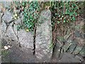
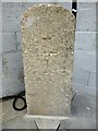
Old Boundary Marker
Parish Boundary Marker on the east side of the Coldstyle Road, set in a wall to the right of the entrance drive to a house. On the former boundary of Liskeard Borough and Liskeard Parish. Inscribed P with B perhaps hidden by the wall.
Milestone Society National ID: CW_LISK02pb
Image: © B Oldham
Taken: 23 Jul 2020
0.11 miles
2
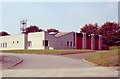
Liskeard Fire Station
Liskeard Fire Station, Greenbank Road, Liskeard, Cornwall.
Image: © Kevin Hale
Taken: 16 Sep 1990
0.12 miles
3
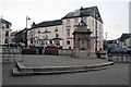
The Parade with the Fountain Inn behind
In the 1980s and before you could park here. Since then it's been paved over. Far more cars about these days and they can be seen here on the right heading towards Plymouth, turn right at the mini roundabout or straight on for Callington.
Image: © roger geach
Taken: 29 Nov 2008
0.22 miles
5
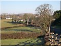
Northern outskirts of Liskeard
In the distance is the television transmission tower on Caradon Hill.
Image: © Tony Atkin
Taken: 28 Dec 2005
0.23 miles
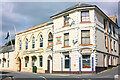
6
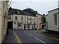
Fountain Hotel, Cornwall
The irregularly-shaped square called The Parade is the site of most of Liskeard's grander town houses. This row is at the northern side, running into Barras Place (left).
"Mid C19 remodelling of probable C18 house. Stucco on studwork; dry Delabole slate roof" - the full description of the hotel is at http://www.imagesofengland.org.uk/Details/Default.aspx?id=382248&mode=adv . The part slate-hung house to its left is also listed, and also part of the hotel - see http://www.imagesofengland.org.uk/Details/Default.aspx?id=382245&mode=adv . For number 2, The Parade, the taller building to the right, see http://www.imagesofengland.org.uk/Details/Default.aspx?id=382244&mode=adv - the building has been repainted since that photo was taken.
View from West Street.
Image: © Derek Harper
Taken: 22 Jan 2009
0.23 miles
7
Old Milestone, formerly by the B3254, north of Trevecca Cottages
Carved stone post formerly by the B3254, North of Trevecca Cottages, in parish of LISKEARD (CARADON District). Removed to unidentified location in Addington, Liskeard. Launceston pillar, erected by the Liskeard turnpike trust in the 18th century.
Inscription reads:-
L
1
Grade II listed.
List Entry Number: 1203192 https://historicengland.org.uk/listing/the-list/list-entry/1203192
Milestone Society National ID: CW_LKCE01.
Image: © Rosy Hanns
Taken: 20 May 2019
0.24 miles
8
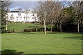
Westbourne Gardens
All of this used to be the private gardens of the large house but now the gardens in the foreground are public and those behind the hedge are still private. It is called a garden but is little more than lawn and trees on both sides of the hedge.
Image: © Tony Atkin
Taken: 10 Mar 2007
0.24 miles