IMAGES TAKEN NEAR TO
Dark Lane, LISKEARD, PL14 3HT
Introduction
This page details the photographs taken nearby to Dark Lane, PL14 3HT by members of the Geograph project.
The Geograph project started in 2005 with the aim of publishing, organising and preserving representative images for every square kilometre of Great Britain, Ireland and the Isle of Man.

There are currently over 7.5m images from over14,400 individuals and you can help contribute to the project by visiting https://www.geograph.org.uk
Image Map (Loading...)


Getting Data...Please wait
Leaflet Map data © OpenStreetMap
Images are licensed for reuse under creativecommons.org/licenses/by-sa/2.0
Notes
- Clicking on the map will re-center to the selected point.
- The higher the marker number, the further away the image location is from the centre of the postcode.
Image Listing (7 Images Found)
Images are licensed for reuse under creativecommons.org/licenses/by-sa/2.0
Image
Details
Distance
1
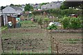
Allotment Gardens and New Housing Estate, Liskeard
Image: © Tony Atkin
Taken: 13 May 2006
0.08 miles
2
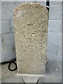
Old Milestone, formerly by the B3254, north of Trevecca Cottages
Carved stone post formerly by the B3254, North of Trevecca Cottages, in parish of LISKEARD (CARADON District). Removed to unidentified location in Addington, Liskeard. Launceston pillar, erected by the Liskeard turnpike trust in the 18th century.
Inscription reads:-
L
1
Grade II listed.
List Entry Number: 1203192 https://historicengland.org.uk/listing/the-list/list-entry/1203192
Milestone Society National ID: CW_LKCE01.
Image: © Rosy Hanns
Taken: 20 May 2019
0.10 miles
3
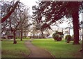
Castle Park, Liskeard
A green space on the eastern side of the town.
Image: © Humphrey Bolton
Taken: 9 Mar 2001
0.21 miles
4
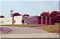
Liskeard Fire Station
Liskeard Fire Station, Greenbank Road, Liskeard, Cornwall.
Image: © Kevin Hale
Taken: 16 Sep 1990
0.22 miles
5
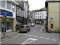
Street view in Liskeard
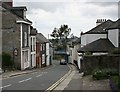
Taken from the bottom of Pike Street, where it seems to become Market Street for a short distance. The white shop centre right bears the name 'Ough's'.
How this is pronounced I do not know - Uff's? Ow's? Oo's? (could be confusing)
Off's? Oh's?
Image: © Dr Neil Clifton
Taken: 30 Mar 2009
0.23 miles
6
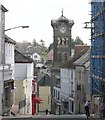
Liskeard town centre
The town of Liskeard is built at the head of a steep valley and spreads out onto the plateau above. This photograph looks east across the town centre valley. The Guildhall Clocktower rises above the level of the surrounding buildings.
Image: © Tony Atkin
Taken: 9 Apr 2004
0.24 miles