IMAGES TAKEN NEAR TO
Musca Close, LISKEARD, PL14 3GW
Introduction
This page details the photographs taken nearby to Musca Close, PL14 3GW by members of the Geograph project.
The Geograph project started in 2005 with the aim of publishing, organising and preserving representative images for every square kilometre of Great Britain, Ireland and the Isle of Man.

There are currently over 7.5m images from over14,400 individuals and you can help contribute to the project by visiting https://www.geograph.org.uk
Image Map
Images are licensed for reuse under creativecommons.org/licenses/by-sa/2.0
Notes
- Clicking on the map will re-center to the selected point.
- The higher the marker number, the further away the image location is from the centre of the postcode.
Image Listing (16 Images Found)
Images are licensed for reuse under creativecommons.org/licenses/by-sa/2.0
Image
Details
Distance
2
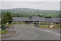
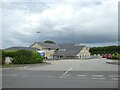
Liskeard Community Hospital
This new community hospital offers a far more limited range of treatments than a large general hospital, but at least it is close to the people who need to use it.
Image: © Tony Atkin
Taken: 13 May 2006
0.10 miles
3
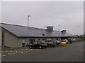
The New Liskeard Hospital
Constructed recently to replace the old Passmore Edwards hospital in Liskeard Town Centre, the new Liskeard Hospital is a welcome addition to local health services, as well as looking ultra modern with a pleasing design.
Image: © Eric Foster
Taken: 17 Aug 2011
0.10 miles


8
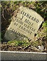
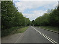
Old Milestone by the A390, west of Hendrabridge
Carved stone post by the A390, in parish of LISKEARD (CARADON District), Hendrabridge, by minor crossroads, set into Cornish hedge, on North side of road. Gravestone, erected by the Liskeard turnpike trust in the 19th century.
Inscription reads:-
LISKEARD
1 MILE
FROM CENTRE
OF PARADE
----
CALLINGTON
7½
Grade II Listed. List Entry Number: 1203155
https://historicengland.org.uk/listing/the-list/list-entry/1203155
Milestone Society National ID: CW_LKCL01.
Image: © Ian Thompson
Taken: 1 Jul 2001
0.16 miles
9
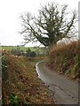
Bridleway near Hendra Bridge
Bridleway 615/16/2 runs towards an abattoir in the valley of the River Seaton.
Image: © Derek Harper
Taken: 22 Jan 2009
0.16 miles
10
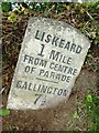
Old Milestone by the A390, west of Hendrabridge
Carved stone post by the A390, in parish of LISKEARD (CARADON District), Hendrabridge, by minor crossroads, set into Cornish hedge, on North side of road. Gravestone, erected by the Liskeard turnpike trust in the 19th century.
Inscription reads:-
LISKEARD
1 MILE
FROM CENTRE
OF PARADE
----
CALLINGTON
7½
Grade II listed.
List Entry Number: 1203155 https://historicengland.org.uk/listing/the-list/list-entry/1203155
Milestone Society National ID: CW_LKCL01.
Image: © Rosy Hanns
Taken: 20 May 2019
0.16 miles