IMAGES TAKEN NEAR TO
Admiralty Road, PLYMOUTH, PL1 3RS
Introduction
This page details the photographs taken nearby to Admiralty Road, PL1 3RS by members of the Geograph project.
The Geograph project started in 2005 with the aim of publishing, organising and preserving representative images for every square kilometre of Great Britain, Ireland and the Isle of Man.

There are currently over 7.5m images from over14,400 individuals and you can help contribute to the project by visiting https://www.geograph.org.uk
Image Map (Loading...)


Getting Data...Please wait
Leaflet Map data © OpenStreetMap
Images are licensed for reuse under creativecommons.org/licenses/by-sa/2.0
Notes
- Clicking on the map will re-center to the selected point.
- The higher the marker number, the further away the image location is from the centre of the postcode.
Image Listing (564 Images Found)
Images are licensed for reuse under creativecommons.org/licenses/by-sa/2.0
Image
Details
Distance
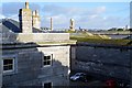
1
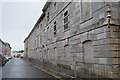
Royal William Victualling Yard - wall
Grade II* listed. http://www.britishlistedbuildings.co.uk/en-476491-rear-retaining-wall-extending-approximat
Image: © N Chadwick
Taken: 28 Nov 2015
0.01 miles

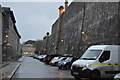
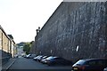
3
Royal William Victualling Yard - wall
Grade II* listed. http://www.britishlistedbuildings.co.uk/en-476491-rear-retaining-wall-extending-approximat
Image: © N Chadwick
Taken: 28 Nov 2015
0.01 miles
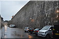
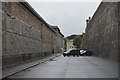
4
Royal William Victualling Yard - wall
Grade II* listed. http://www.britishlistedbuildings.co.uk/en-476491-rear-retaining-wall-extending-approximat
Image: © N Chadwick
Taken: 28 Nov 2015
0.02 miles
5
Royal William Victualling Yard - roofscape
Image: © N Chadwick
Taken: 1 Jan 2018
0.03 miles
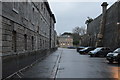
6
Royal William Yard - rear retaining wall
Grade II* listed. https://britishlistedbuildings.co.uk/101378541-rear-retaining-wall-extending-approximately-400-metres-royal-william-victualling-yard-st-peter-and-the-waterfront-ward
Image: © N Chadwick
Taken: 5 Aug 2018
0.03 miles
8
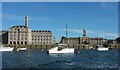
Buildings at Royal William Victualling Yard
A view from the Cremyll Ferry. On the left is the grade I listed Mills Bakery http://list.historicengland.org.uk/resultsingle.aspx?uid=1378532&searchtype=mapsearch , incorporating granary, store and bakery, and now apartments, offices, retail and leisure. Right of centre is Melville, again grade I listed, "built as a general store for clothing and food, and as offices for the Officers and clerks of the Yard ... Melville is the centrepiece of the very fine composed seaward front to Royal William". Also grade I listed, the quay wall is described at http://list.historicengland.org.uk/resultsingle.aspx?uid=1378533&searchtype=mapsearch .
Image: © Derek Harper
Taken: 8 Aug 2015
0.04 miles
9
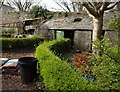
Garden shed, Royal William Yard
One of the walled gardens at Royal William Yard, which I understand is run by the charity Groundwork.
Image: © Derek Harper
Taken: 26 Mar 2011
0.04 miles