IMAGES TAKEN NEAR TO
Clarence Place, PLYMOUTH, PL1 3JW
Introduction
This page details the photographs taken nearby to Clarence Place, PL1 3JW by members of the Geograph project.
The Geograph project started in 2005 with the aim of publishing, organising and preserving representative images for every square kilometre of Great Britain, Ireland and the Isle of Man.

There are currently over 7.5m images from over14,400 individuals and you can help contribute to the project by visiting https://www.geograph.org.uk
Image Map
Images are licensed for reuse under creativecommons.org/licenses/by-sa/2.0
Notes
- Clicking on the map will re-center to the selected point.
- The higher the marker number, the further away the image location is from the centre of the postcode.
Image Listing (335 Images Found)
Images are licensed for reuse under creativecommons.org/licenses/by-sa/2.0
Image
Details
Distance


7
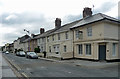
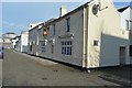
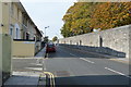
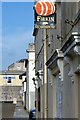
2-23 Clarence Place, Plymouth
Part of an early C19th planned development. Grade II listed.
The corner house was originally a pub, latterly the Prince Alfred, and was converted to a dwelling in 2012.
Image: © Stephen Richards
Taken: 16 Jun 2014
0.05 miles
8
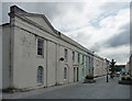
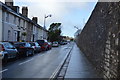
Adelaide Street, Plymouth
A fragment of a John Foulston scheme, c1820, "pedestrianized and half-heartedly restored in the 1970s". Grade II listed.
Image: © Stephen Richards
Taken: 16 Jun 2014
0.05 miles