IMAGES TAKEN NEAR TO
Langreek Bungalows, LOOE, PL13 2PP
Introduction
This page details the photographs taken nearby to Langreek Bungalows, PL13 2PP by members of the Geograph project.
The Geograph project started in 2005 with the aim of publishing, organising and preserving representative images for every square kilometre of Great Britain, Ireland and the Isle of Man.

There are currently over 7.5m images from over14,400 individuals and you can help contribute to the project by visiting https://www.geograph.org.uk
Image Map
Images are licensed for reuse under creativecommons.org/licenses/by-sa/2.0
Notes
- Clicking on the map will re-center to the selected point.
- The higher the marker number, the further away the image location is from the centre of the postcode.
Image Listing (4 Images Found)
Images are licensed for reuse under creativecommons.org/licenses/by-sa/2.0
Image
Details
Distance
1
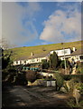
Langreek Bungalows
The description at Image discusses the spelling of the name. In the foreground is Langreek Road. The bungalows (one of which isn't truly a bungalow any more) are at the edge of the built-up area of Crumplehorn.
Image: © Derek Harper
Taken: 4 Feb 2015
0.02 miles
2
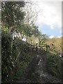
Bridleway to Lannear
The lower, eastern, start of bridleway 612 5/1, seen crossing the hillside in Image This view is from Langreek Road.
Image: © Derek Harper
Taken: 4 Feb 2015
0.03 miles
3
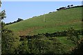
The Hillside near Lannear
Looking across the valley to the steep hillside on the other side. Taken from the road which descends steeply towards Polperro.
Image: © Tony Atkin
Taken: 27 Sep 2009
0.10 miles
4
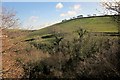
Hillside near Lannear
A slightly wider view of the hillside shown in Image Descending across it from right to left is a track carrying bridleway 612 5/1 from Lannear to Crumplehorn.
Image: © Derek Harper
Taken: 4 Feb 2015
0.16 miles