IMAGES TAKEN NEAR TO
LOOE, PL13 2ND
Introduction
This page details the photographs taken nearby to PL13 2ND by members of the Geograph project.
The Geograph project started in 2005 with the aim of publishing, organising and preserving representative images for every square kilometre of Great Britain, Ireland and the Isle of Man.

There are currently over 7.5m images from over14,400 individuals and you can help contribute to the project by visiting https://www.geograph.org.uk
Image Map
Images are licensed for reuse under creativecommons.org/licenses/by-sa/2.0
Notes
- Clicking on the map will re-center to the selected point.
- The higher the marker number, the further away the image location is from the centre of the postcode.
Image Listing (21 Images Found)
Images are licensed for reuse under creativecommons.org/licenses/by-sa/2.0
Image
Details
Distance


3
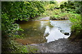
Milcombe Tidal Ford
This ford is found close to Watergate.
Image: © John Walton
Taken: 20 Sep 2015
0.06 miles
4
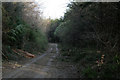
Track in Polzion Wood
A shaft of sunlight catches the golden leaves on a beech sapling. The wood is mainly coniferous with a scattering of what are probably the original native species. The planted larch are being felled due as a precaution against Phytophthora ramorum.
Image: © David Lally
Taken: 12 Apr 2011
0.10 miles
5
West Looe River south of Sowden's Bridge
Image: © Tony Atkin
Taken: 13 Nov 2005
0.11 miles
6
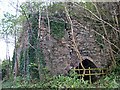
Old Direction Sign - Signpost south of Milcombe
Lost finial - 2 arms; by the UC road, in parish of Pelynt (Caradon District), Kiln Wood.
To be surveyed
Milestone Society National ID: CW_SX2355A.
Image: © Milestone Society
Taken: Unknown
0.13 miles
7
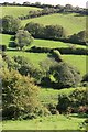
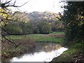
West Looe river valley
The river is hidden in the foreground by the trees the land then rises steeply and is mostly pasture around here as it's too steep to cultivate.
Image: © roger geach
Taken: 10 Oct 2009
0.13 miles
9
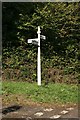
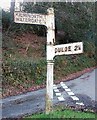
Signpost nr Sowdens Bridge
Duloe straight on , Pelynt towards the left and Watergate and Trelawne behind the photographer. These are all narrow country roads.
Image: © roger geach
Taken: 10 Oct 2009
0.14 miles
10
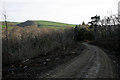
Track through a felled area
In Kiln Wood, larch has been cleared due to an infection of Phytophthora ramorum. A fact I was unaware of at the time this was taken.
Image: © David Lally
Taken: 12 Apr 2011
0.14 miles