IMAGES TAKEN NEAR TO
Pelynt, LOOE, PL13 2LZ
Introduction
This page details the photographs taken nearby to PL13 2LZ by members of the Geograph project.
The Geograph project started in 2005 with the aim of publishing, organising and preserving representative images for every square kilometre of Great Britain, Ireland and the Isle of Man.

There are currently over 7.5m images from over14,400 individuals and you can help contribute to the project by visiting https://www.geograph.org.uk
Image Map (Loading...)


Getting Data...Please wait
Leaflet Map data © OpenStreetMap
Images are licensed for reuse under creativecommons.org/licenses/by-sa/2.0
Notes
- Clicking on the map will re-center to the selected point.
- The higher the marker number, the further away the image location is from the centre of the postcode.
Image Listing (17 Images Found)
Images are licensed for reuse under creativecommons.org/licenses/by-sa/2.0
Image
Details
Distance
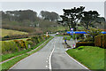

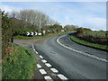
4

The A387 looking towards Polperro
Polperro park filling station can be seen in the distance. The road is quiet today for a June Sunday with not many people about.
Image: © roger geach
Taken: 24 Jun 2012
0.06 miles
5
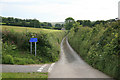
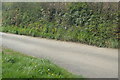
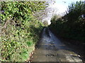
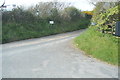
Narrow Lane
The view down this typical narrow Cornish lane looking towards West Watergate
Image: © roger geach
Taken: 24 Jun 2012
0.07 miles
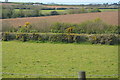
10
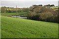
Green Valley
This shallow valley turns into a deep v shaped valley just to the south of here as it goes down to Polperro.
Image: © Tony Atkin
Taken: 13 Nov 2005
0.12 miles