IMAGES TAKEN NEAR TO
Widegates, LOOE, PL13 1QJ
Introduction
This page details the photographs taken nearby to PL13 1QJ by members of the Geograph project.
The Geograph project started in 2005 with the aim of publishing, organising and preserving representative images for every square kilometre of Great Britain, Ireland and the Isle of Man.

There are currently over 7.5m images from over14,400 individuals and you can help contribute to the project by visiting https://www.geograph.org.uk
Image Map (Loading...)


Getting Data...Please wait
Leaflet Map data © OpenStreetMap
Images are licensed for reuse under creativecommons.org/licenses/by-sa/2.0
Notes
- Clicking on the map will re-center to the selected point.
- The higher the marker number, the further away the image location is from the centre of the postcode.
Image Listing (7 Images Found)
Images are licensed for reuse under creativecommons.org/licenses/by-sa/2.0
Image
Details
Distance
1
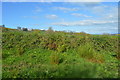
Bales, Lydcott Lane, Widegates
Pile of bales, Lydcott Lane, Widegates, Cornwall.
Image: © Kevin Hale
Taken: 24 Jun 2006
0.12 miles
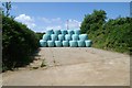
2
Lydcott Lane, Widegates
Shed at Lydcott Lane, Widegates, Cornwall.
Image: © Kevin Hale
Taken: 24 Jun 2006
0.12 miles
3
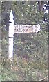
Old Direction Sign - Signpost by the A387, Tredinnick Lane End, Morval Parish
Pyramid finial - 1 arm; Cornwall CC iron spear by the A387, in parish of Morval (Caradon District), Tredinnick Lane End, on verge beside field gate.
To be surveyed
Milestone Society National ID: CW_SX2957
Image: © Milestone Society
Taken: Unknown
0.22 miles
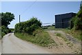
4
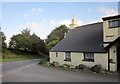
House at Tredinnick Lane End
At the junction of the lane to Trelowia with the A387. A George V letters only postbox, number PL13 128, is on the wall.
Image: © Derek Harper
Taken: 10 Sep 2014
0.23 miles
5
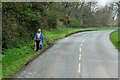
Dog-walkers on the A387 near Wildegates
Image: © David Dixon
Taken: 13 Apr 2022
0.24 miles
6
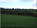
Grazing, Tredinnick Lane-end
North of the A387..
Image: © JThomas
Taken: 7 Nov 2014
0.24 miles