IMAGES TAKEN NEAR TO
Widegates, LOOE, PL13 1PZ
Introduction
This page details the photographs taken nearby to PL13 1PZ by members of the Geograph project.
The Geograph project started in 2005 with the aim of publishing, organising and preserving representative images for every square kilometre of Great Britain, Ireland and the Isle of Man.

There are currently over 7.5m images from over14,400 individuals and you can help contribute to the project by visiting https://www.geograph.org.uk
Image Map
Images are licensed for reuse under creativecommons.org/licenses/by-sa/2.0
Notes
- Clicking on the map will re-center to the selected point.
- The higher the marker number, the further away the image location is from the centre of the postcode.
Image Listing (2 Images Found)
Images are licensed for reuse under creativecommons.org/licenses/by-sa/2.0
Image
Details
Distance
1
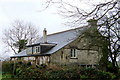
House in Tregastick
This is a House in Tregastick as depicted on the map. The owners look like they have just had a running battle with some Hedera, which is the latin name for ivy. Mythically, it is considered a symbol of woman. If put together with Holly (the symbol of man) at Christmas, it would bring peace in a home between a husband and wife, for the following year....
Image: © BB
Taken: 19 Feb 2007
0.06 miles
2
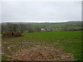
View across farmland to farm
Typical view across farmland where the viewer can see an adjacent farm - as depicted by the OS grid square.
Image: © BB
Taken: 19 Feb 2007
0.23 miles