IMAGES TAKEN NEAR TO
Morval, LOOE, PL13 1PN
Introduction
This page details the photographs taken nearby to PL13 1PN by members of the Geograph project.
The Geograph project started in 2005 with the aim of publishing, organising and preserving representative images for every square kilometre of Great Britain, Ireland and the Isle of Man.

There are currently over 7.5m images from over14,400 individuals and you can help contribute to the project by visiting https://www.geograph.org.uk
Image Map (Loading...)


Getting Data...Please wait
Leaflet Map data © OpenStreetMap
Images are licensed for reuse under creativecommons.org/licenses/by-sa/2.0
Notes
- Clicking on the map will re-center to the selected point.
- The higher the marker number, the further away the image location is from the centre of the postcode.
Image Listing (15 Images Found)
Images are licensed for reuse under creativecommons.org/licenses/by-sa/2.0
Image
Details
Distance
1
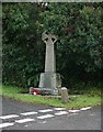
On the road Junction
War memorial situated on the road junction.
Image: © roger geach
Taken: 10 Oct 2009
0.02 miles
2
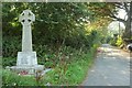
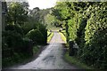
Lane at Leyland
With the war memorial shown in Image in the foreground. The lane leads from the junction on the A387 to Morval.
Image: © Derek Harper
Taken: 10 Sep 2015
0.04 miles
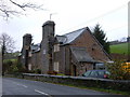
3
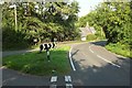
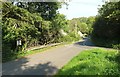
Junction on A387 at Leyland
The grass triangle is at the junction of the lane shown in Image See also Image The Memorial Hall and Old School House described at http://www.historicengland.org.uk/listing/the-list/list-entry/1329321 are seen a little more here.
Image: © Derek Harper
Taken: 10 Sep 2015
0.06 miles
4
Postbox on the A387 at Morval
Seen from the road Junction that leads to Morval Church this is the road leading towards Looe.
Image: © roger geach
Taken: 10 Oct 2009
0.08 miles
5
Private road
This road leads to Morval house and estate.
Image: © roger geach
Taken: 10 Oct 2009
0.09 miles
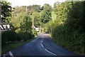
6
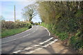
A387 at Leyland
Part of this image is almost identical to Image, but there is a little more context here, with the grass triangle at the junction of the lane shown in Image Roger's photo shows more clearly than mine the building in the left, the Memorial Hall and Old School House described at http://www.historicengland.org.uk/listing/the-list/list-entry/1329321 . At the corner, mrely glimpsed in both images, are Leyland Almshouses http://www.historicengland.org.uk/listing/the-list/list-entry/1140270 .
Image: © Derek Harper
Taken: 10 Sep 2015
0.10 miles
7
A 387 at Morval
Looking towards Torwell.
Image: © Trevor Harris
Taken: 5 Apr 2017
0.11 miles
8
Towards Torwell
From the same spot on the A237 shown in Image], looking across the main road and up the hillside to a house at Torwell.
Image: © Derek Harper
Taken: 10 Sep 2015
0.12 miles
9
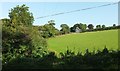
A funky house
The image subject is within grid square SX2557 and the photographer was too.
You can clearly see the main geographical features within the square - such as the house itself, the A387 Road, and the hill behind.
Image: © BB
Taken: 19 Feb 2007
0.17 miles
10
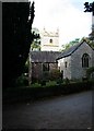
Morval Church and tower
Seen from the quiet road just outside the church. The new churchyard is behind me up a path.
Image: © roger geach
Taken: 10 Oct 2009
0.22 miles