IMAGES TAKEN NEAR TO
Tregarland Bridge, LOOE, PL13 1PL
Introduction
This page details the photographs taken nearby to PL13 1PL by members of the Geograph project.
The Geograph project started in 2005 with the aim of publishing, organising and preserving representative images for every square kilometre of Great Britain, Ireland and the Isle of Man.

There are currently over 7.5m images from over14,400 individuals and you can help contribute to the project by visiting https://www.geograph.org.uk
Image Map
Images are licensed for reuse under creativecommons.org/licenses/by-sa/2.0
Notes
- Clicking on the map will re-center to the selected point.
- The higher the marker number, the further away the image location is from the centre of the postcode.
Image Listing (21 Images Found)
Images are licensed for reuse under creativecommons.org/licenses/by-sa/2.0
Image
Details
Distance
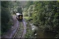
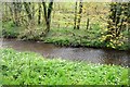
1
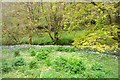
Woodland, River and Rail
This is taken from the bridge at Tregarlandbridge. The Looe Valley railway line runs parallel to the river along the length of this valley. The railway line itself replaced an earlier canal.
Image: © Tony Atkin
Taken: 29 Oct 2006
0.02 miles
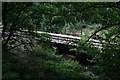
2
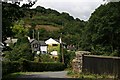
Houses in The Looe Valley
Taken from a bridge over the railway line.
Image: © Tony Atkin
Taken: 13 Aug 2006
0.02 miles
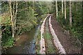
5
Stream under Railway Line
Looking down onto the Looe Valley Railway Line from a woodland path at a point where the stream crosses underneath the line.
Image: © Tony Atkin
Taken: 13 Aug 2006
0.07 miles