IMAGES TAKEN NEAR TO
St. Martin, LOOE, PL13 1PB
Introduction
This page details the photographs taken nearby to PL13 1PB by members of the Geograph project.
The Geograph project started in 2005 with the aim of publishing, organising and preserving representative images for every square kilometre of Great Britain, Ireland and the Isle of Man.

There are currently over 7.5m images from over14,400 individuals and you can help contribute to the project by visiting https://www.geograph.org.uk
Image Map (Loading...)


Getting Data...Please wait
Leaflet Map data © OpenStreetMap
Images are licensed for reuse under creativecommons.org/licenses/by-sa/2.0
Notes
- Clicking on the map will re-center to the selected point.
- The higher the marker number, the further away the image location is from the centre of the postcode.
Image Listing (7 Images Found)
Images are licensed for reuse under creativecommons.org/licenses/by-sa/2.0
Image
Details
Distance
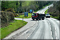
3
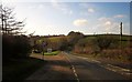
B3253 past Tregoad Farm
The road crosses a dip, in effect a col between two deep valleys, the one on the right part of the system shown in Image], the one on the left dropping to the sea at Millendreath.
Image: © Derek Harper
Taken: 4 Feb 2015
0.12 miles
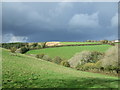
5
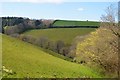
Valley near Morval
From the B3253 near Tregoad Farm.
Image: © Derek Harper
Taken: 4 Feb 2015
0.18 miles