IMAGES TAKEN NEAR TO
Lower Street, LOOE, PL13 1DA
Introduction
This page details the photographs taken nearby to Lower Street, PL13 1DA by members of the Geograph project.
The Geograph project started in 2005 with the aim of publishing, organising and preserving representative images for every square kilometre of Great Britain, Ireland and the Isle of Man.

There are currently over 7.5m images from over14,400 individuals and you can help contribute to the project by visiting https://www.geograph.org.uk
Image Map
Images are licensed for reuse under creativecommons.org/licenses/by-sa/2.0
Notes
- Clicking on the map will re-center to the selected point.
- The higher the marker number, the further away the image location is from the centre of the postcode.
Image Listing (535 Images Found)
Images are licensed for reuse under creativecommons.org/licenses/by-sa/2.0
Image
Details
Distance
1
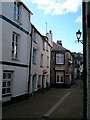
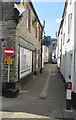
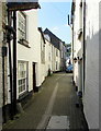
Narrow Lane
There are several of these narrow lanes in the harbour entrance area of East Looe. In the background is the tower of the parish church of St Anne.
Image: © mike smith
Taken: 24 Jul 2007
0.00 miles
2

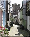
Tiree 'n' Tyrina, Lower Chapel Street, East Looe
Two adjoining Grade II listed former fishermen's cottages dating from the 18th century. Now in use as holiday rental cottages.
Image: © Jaggery
Taken: 28 May 2018
0.01 miles
3
Osborne House, Lower Chapel Street, East Looe
Grade II listed building dating from the 18th century.
Image: © Jaggery
Taken: 28 May 2018
0.01 miles
4
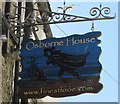
Osborne House name sign, Lower Chapel Street, East Looe
Hanging from a wall bracket here. https://www.geograph.org.uk/photo/5822806
Image: © Jaggery
Taken: 28 May 2018
0.01 miles
5
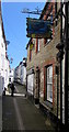
No Entry sign and Restricted Parking Zone sign, Lower Chapel Street, East Looe
Wider behind the camera, Lower Chapel Street is narrow ahead.
Image: © Jaggery
Taken: 28 May 2018
0.01 miles
6
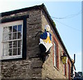
18th century style depiction above Lower Chapel Street, East Looe
In June 2018 there was no plaque or notice to explain the significance of this male figure in 18th century clothing located here. https://www.geograph.org.uk/photo/5822831
Image: © Jaggery
Taken: 28 May 2018
0.01 miles
7
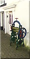
Old mangle, Lower Chapel Street, East Looe
Located here, https://www.geograph.org.uk/photo/5822786 the mangle is a hand-turned device with rollers for squeezing water out of wet washing,
used in the era before electric washing machines. This mangle was made by Priests Ltd Plymouth. https://www.geograph.org.uk/photo/5822801
Image: © Jaggery
Taken: 28 May 2018
0.02 miles
8
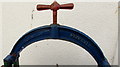
Old mangle detail, Lower Chapel Street, East Looe
The name embossed on the top of this https://www.geograph.org.uk/photo/5822796 mangle is PRIESTS LTD PLYMOUTH.
Image: © Jaggery
Taken: 28 May 2018
0.02 miles
9
Lower Chapel Street towards Buller Street, East Looe
One of several parallel narrow streets in the southeast part of East Looe.
Image: © Jaggery
Taken: 28 May 2018
0.02 miles