1
Sea View Cottages, East Looe
Row of houses located between Lower Chapel Street and Church End.
Image: © Jaggery
Taken: 28 May 2018
0.00 miles
2
St Mary's Church, Looe
Grade II listed. Listing number 1201107. The church was dedicated by Walter Branscombe, Bishop of Exeter in 1259. The tower dates from the 15th century, but the rest was largely rebuilt in 1806. This 1806 building survived until replaced in 1882.
Image: © Andrew Abbott
Taken: 18 Nov 2017
0.00 miles
3
OS benchmark - Looe, St Mary's church
An OS cutmark on the buttress at the SW angle of the church; originally levelled, probably in 1973, at 4.363m above Ordnance Datum Newlyn.
Image: © Richard Law
Taken: 13 Oct 2016
0.01 miles
4
Church End car park, East Looe
The Grade II listed former St Mary's Church https://www.geograph.org.uk/photo/5822848 is in the background.
Image: © Jaggery
Taken: 28 May 2018
0.01 miles
5
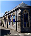
South side of the Grade II listed former St Mary's Church, East Looe
Viewed across Lower Chapel Street. The church was dedicated by Walter Branscombe, Bishop of Exeter, in 1259. The tower dates from the 15th century. The rest of the church was largely rebuilt in 1806. This 1806 building was replaced in 1882. Grade II listed in 1973. In the 1980s the church was declared redundant by the Church of England (Diocese of Truro). In the 1990s the building was acquired by the Westcountry Housing Association for conversion to sheltered accommodation.
Image: © Jaggery
Taken: 28 May 2018
0.01 miles
6
OS benchmark - Looe, Watchtower Studio at Church End
An OS cutmark on a building near the Lifeboat Station (described as the Watchtower Studio by the OS when the mark was made, but now a purveyor of beach goods.) It was originally levelled, probably in 1973, at 5.087m above Ordnance Datum Newlyn.
Image: © Richard Law
Taken: 13 Oct 2016
0.01 miles
7
Sea Breeze, Lower Chapel Street, East Looe
Guesthouse at 3-4 Lower Chapel Street.
https://www.geograph.org.uk/photo/5822825 to the name sign.
Image: © Jaggery
Taken: 28 May 2018
0.01 miles
8
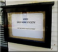
Looe Sarcasm Society noticeboard, Lower Chapel Street, East Looe
On the left here. https://www.geograph.org.uk/photo/5822820
Image: © Jaggery
Taken: 28 May 2018
0.01 miles
9
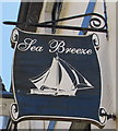
Sea Breeze name sign, Lower Chapel Street, East Looe
Hanging from a wall bracket here. https://www.geograph.org.uk/photo/5822820
Image: © Jaggery
Taken: 28 May 2018
0.01 miles
10
West side of the former St Mary's Church, East Looe
Viewed across Lower Chapel Street. The church was dedicated by Walter Branscombe, Bishop of Exeter, in 1259. The tower dates from the 15th century. The rest of the church was largely rebuilt in 1806. This 1806 building was replaced in 1882. Grade II listed in 1973. In the 1980s the church was declared redundant by the Church of England (Diocese of Truro). In the 1990s the building was acquired by the Westcountry Housing Association for conversion to sheltered accommodation.
Image: © Jaggery
Taken: 28 May 2018
0.01 miles


