IMAGES TAKEN NEAR TO
Lockyer Street, PLYMOUTH, PL1 2PX
Introduction
This page details the photographs taken nearby to Lockyer Street, PL1 2PX by members of the Geograph project.
The Geograph project started in 2005 with the aim of publishing, organising and preserving representative images for every square kilometre of Great Britain, Ireland and the Isle of Man.

There are currently over 7.5m images from over14,400 individuals and you can help contribute to the project by visiting https://www.geograph.org.uk
Image Map
Images are licensed for reuse under creativecommons.org/licenses/by-sa/2.0
Notes
- Clicking on the map will re-center to the selected point.
- The higher the marker number, the further away the image location is from the centre of the postcode.
Image Listing (1907 Images Found)
Images are licensed for reuse under creativecommons.org/licenses/by-sa/2.0
Image
Details
Distance
1
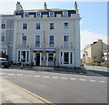
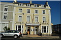
Invicta Hotel, Plymouth
At 11-12 Osborne Place on the corner of Citadel Road. Built in the mid 19th century as a pair of houses in a planned street. Historic England records that this building was part of an important planned group of terraces and villas by
Foulston and his pupil Wightwick on the Hoe, a scheme which placed Plymouth in the forefront of town planning in the early-mid 19th century. Invicta Hotel was Grade II listed in 1998.
Image: © Jaggery
Taken: 14 Jul 2018
0.01 miles
2
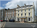
9-12 Osborne Place, Plymouth
Two-thirds of Neopolitan ice-cream. Mid C19th. Nos. 11-12, the vanilla bit, is grade II listed.
It is now the Invicta Hotel; the chocolate bit is the Bowling Green Hotel.
Image: © Stephen Richards
Taken: 15 Jun 2014
0.01 miles
4
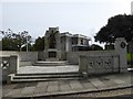
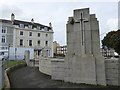
Plymouth city war memorial, Citadel road
The plaque reads that this is a tribute from the City of Plymouth to her glorious dead (in both world wars) with a roll of honour in a vault and a duplicate in the possession of the mayor. The upright on the right is one of four, inscribed: Honour, Duty, Freedom, Sacrifice
Image: © David Smith
Taken: 29 Sep 2017
0.02 miles
5
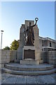
Rear of Plymouth city war memorial
The sword forms a cross on the back of the monument Image], which is otherwise without religious symbolism
Image: © David Smith
Taken: 29 Sep 2017
0.02 miles
6
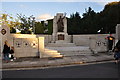
Plymouth : War Memorial
War memorial. c1920 to those of Plymouth who died in World Wars I and II. Bronze Classical female figure holding wreath, set on granite plinth in front of polished pink granite buttressed pier on plinth with bronze plaques. The monument is set at the rear of a granite ashlar curved low-walled enclosure with wide front entrance with steps flanked by latticed balustrades. One of a fine group of memorials on the Hoe.
Image: © Lewis Clarke
Taken: 13 Aug 2014
0.02 miles
8
War Memorial
Grade II listed. https://britishlistedbuildings.co.uk/101113346-war-memorial-at-north-west-corner-of-the-hoe-st-peter-and-the-waterfront-ward
Image: © N Chadwick
Taken: 5 Aug 2018
0.02 miles
9
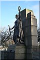
Plymouth War Memorial
Situated on a corner of Plymouth Hoe near Lockyer Street, this memorial was built in 1923 in memory of those who died in 'The Great War'. Now it also serves as a memorial to the dead of the Second World War.
Image: © Tony Atkin
Taken: 6 Jan 2007
0.02 miles
10
Plymouth city war memorial, The Hoe
Installed c.1920 to commemorate citizens who died in WWI, later including the victims of WWII. Listed Grade II.
Image: © Alan Murray-Rust
Taken: 29 Jun 2023
0.03 miles