IMAGES TAKEN NEAR TO
Sussex Place, PLYMOUTH, PL1 2HT
Introduction
This page details the photographs taken nearby to Sussex Place, PL1 2HT by members of the Geograph project.
The Geograph project started in 2005 with the aim of publishing, organising and preserving representative images for every square kilometre of Great Britain, Ireland and the Isle of Man.

There are currently over 7.5m images from over14,400 individuals and you can help contribute to the project by visiting https://www.geograph.org.uk
Image Map
Images are licensed for reuse under creativecommons.org/licenses/by-sa/2.0
Notes
- Clicking on the map will re-center to the selected point.
- The higher the marker number, the further away the image location is from the centre of the postcode.
Image Listing (2492 Images Found)
Images are licensed for reuse under creativecommons.org/licenses/by-sa/2.0
Image
Details
Distance
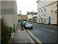
1
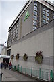
Zion Street, Plymouth
Flats built across the street as it drops towards the city centre.
Image: © Hugh Venables
Taken: 6 Jun 2009
0.02 miles
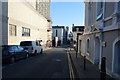
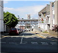
2
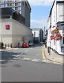
Sussex Street, Plymouth
From the north side of Citadel Road, Sussex Street leads to Sussex Place.
The Crowne Plaza Hotel https://www.geograph.org.uk/photo/5848291 is on the left.
The Pub on the Hoe https://www.geograph.org.uk/photo/5848306 is on the right.
Image: © Jaggery
Taken: 14 Jul 2018
0.02 miles
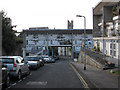
6
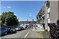
Zion Street housing, Plymouth
Photo number 7577325.
Image: © Robin Stott
Taken: 29 Jun 2023
0.03 miles
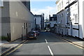
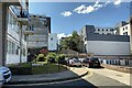
9
Zion Street, Plymouth
On the north side of Citadel Road.
Image: © Jaggery
Taken: 14 Jul 2018
0.03 miles