IMAGES TAKEN NEAR TO
Park Road, SALTASH, PL12 6TL
Introduction
This page details the photographs taken nearby to Park Road, PL12 6TL by members of the Geograph project.
The Geograph project started in 2005 with the aim of publishing, organising and preserving representative images for every square kilometre of Great Britain, Ireland and the Isle of Man.

There are currently over 7.5m images from over14,400 individuals and you can help contribute to the project by visiting https://www.geograph.org.uk
Image Map
Images are licensed for reuse under creativecommons.org/licenses/by-sa/2.0
Notes
- Clicking on the map will re-center to the selected point.
- The higher the marker number, the further away the image location is from the centre of the postcode.
Image Listing (15 Images Found)
Images are licensed for reuse under creativecommons.org/licenses/by-sa/2.0
Image
Details
Distance
2
St Dominick Primary School
The school is framed against some dark shower clouds with the hint of a rainbow in the top right hand corner.
Image: © Tony Atkin
Taken: 9 Dec 2006
0.10 miles
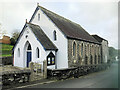
5
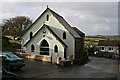
St Dominick Methodist Church
Built in 1896 according to the inscription above the door.
Image: © Tony Atkin
Taken: 9 Dec 2006
0.14 miles
6
Vogus Lane
Last dwelling (to left) along Vogus Lane north-east of Cross.
Image: © Hugh Craddock
Taken: 5 Mar 2011
0.16 miles
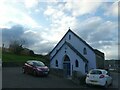
7
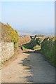
Back road at Cross
One limb of two backroads to Stockwell, forming a triangle to the west of the main road.
Image: © Hugh Craddock
Taken: 5 Mar 2011
0.17 miles
8
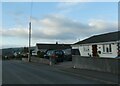
Approaching St Dominick
Looking down to houses on the eastern edge of the village, the grey hills of Dartmoor on the horizon.
Image: © Tony Atkin
Taken: 9 Dec 2006
0.17 miles
9
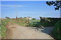
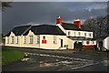
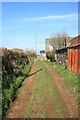
Back road near Cross
Junction adjacent to Pentamar between the two back roads leading to Stockwell. The turning to the right is a metalled public road, and emerges at the Who'd Have Thought It inn http://www.whodhavethoughtitinn.co.uk ; straight on is to St Dominick, status unknown, and unmetalled.
Image: © Hugh Craddock
Taken: 5 Mar 2011
0.18 miles
10
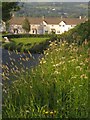
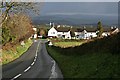
Road to St Dominick
Dropping between grassy banks. The row of houses is at Cross, near the east end of the village.
Image: © Derek Harper
Taken: 7 Jun 2013
0.19 miles