IMAGES TAKEN NEAR TO
Hatt, SALTASH, PL12 6RB
Introduction
This page details the photographs taken nearby to PL12 6RB by members of the Geograph project.
The Geograph project started in 2005 with the aim of publishing, organising and preserving representative images for every square kilometre of Great Britain, Ireland and the Isle of Man.

There are currently over 7.5m images from over14,400 individuals and you can help contribute to the project by visiting https://www.geograph.org.uk
Image Map (4 Images)


Getting Data...Please wait
Leaflet Map data © OpenStreetMap
Images are licensed for reuse under creativecommons.org/licenses/by-sa/2.0
Notes
- Clicking on the map will re-center to the selected point.
- The higher the marker number, the further away the image location is from the centre of the postcode.
Image Listing (4 Images Found)
Images are licensed for reuse under creativecommons.org/licenses/by-sa/2.0
Image
Details
Distance
1
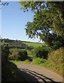
Bridge west of Hatt
Bridge west of Hatt, near Saltash, Cornwall.
Image: © Kevin Hale
Taken: 3 Jun 2006
0.21 miles
2
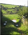
Cock's Lake valley
Looking through the gateway shown in Image
Image: © Derek Harper
Taken: 10 Oct 2013
0.23 miles
3
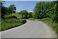
Farmland by Cock's Lake Lane
The lane drops towards the Cock's Lake valley - the woodland is on the slope just beyond the stream. Taken close to the junction with Vollard's Lane.
Image: © Derek Harper
Taken: 10 Oct 2013
0.23 miles
4
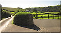
Bend on Cock's Lake Lane
The next sharp bend after Image], a mere 80 metres further on, with a glimpse of the Cock's Lake valley through the gateway.
Image: © Derek Harper
Taken: 10 Oct 2013
0.25 miles