IMAGES TAKEN NEAR TO
South Pill, SALTASH, PL12 6HT
Introduction
This page details the photographs taken nearby to PL12 6HT by members of the Geograph project.
The Geograph project started in 2005 with the aim of publishing, organising and preserving representative images for every square kilometre of Great Britain, Ireland and the Isle of Man.

There are currently over 7.5m images from over14,400 individuals and you can help contribute to the project by visiting https://www.geograph.org.uk
Image Map
Images are licensed for reuse under creativecommons.org/licenses/by-sa/2.0
Notes
- Clicking on the map will re-center to the selected point.
- The higher the marker number, the further away the image location is from the centre of the postcode.
Image Listing (50 Images Found)
Images are licensed for reuse under creativecommons.org/licenses/by-sa/2.0
Image
Details
Distance
1
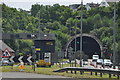
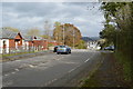
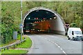
Saltash : The A38
Heading along the A38 with the Saltash Tunnel in view.
Image: © Lewis Clarke
Taken: 17 Jul 2015
0.06 miles
8
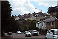
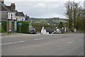
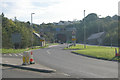
The B3271
Passing through Saltash on New Road, aka the B3271.
Image: © Robert Ashby
Taken: 23 Aug 2014
0.10 miles
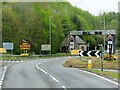
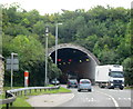
10
Saltash Tunnel (West Portal)
Saltash Tunnel (West Portal), carrying the A38 from Cornwall onto the Saltash Road Bridge into Devon. For the East portal image, see Image
Image: © Kevin Hale
Taken: 17 Oct 2005
0.10 miles