IMAGES TAKEN NEAR TO
Old Ferry Road, SALTASH, PL12 6BL
Introduction
This page details the photographs taken nearby to Old Ferry Road, PL12 6BL by members of the Geograph project.
The Geograph project started in 2005 with the aim of publishing, organising and preserving representative images for every square kilometre of Great Britain, Ireland and the Isle of Man.

There are currently over 7.5m images from over14,400 individuals and you can help contribute to the project by visiting https://www.geograph.org.uk
Image Map
Images are licensed for reuse under creativecommons.org/licenses/by-sa/2.0
Notes
- Clicking on the map will re-center to the selected point.
- The higher the marker number, the further away the image location is from the centre of the postcode.
Image Listing (138 Images Found)
Images are licensed for reuse under creativecommons.org/licenses/by-sa/2.0
Image
Details
Distance
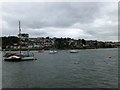
3
Saltash Foreshore
Low tide on the Tamar Estuary.
Image: © Tony Atkin
Taken: 25 May 2008
0.05 miles
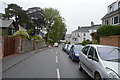
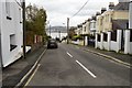
4
Home Park Road, Saltash
Climbing from Old Ferry Road.
Image: © Derek Harper
Taken: 7 Jun 2013
0.06 miles

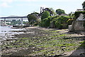
7

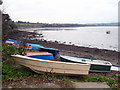
Boats by Brunel Green, Saltash
See also Image This is the northwest corner, with boats drawn up on shingle in the angle beyond, on the edge of the Tamar estuary.
Image: © Derek Harper
Taken: 7 Jun 2013
0.10 miles
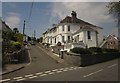
9
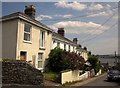
Westbourne Terrace, Saltash
Leading down from Old Ferry Road towards the Tamar estuary.
Image: © Derek Harper
Taken: 7 Jun 2013
0.11 miles
10
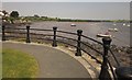
Railings, Brunel Green, Saltash
Curving around the northeast corner of the green shown in Image
Image: © Derek Harper
Taken: 7 Jun 2013
0.12 miles