IMAGES TAKEN NEAR TO
St. Germans, SALTASH, PL12 5PD
Introduction
This page details the photographs taken nearby to PL12 5PD by members of the Geograph project.
The Geograph project started in 2005 with the aim of publishing, organising and preserving representative images for every square kilometre of Great Britain, Ireland and the Isle of Man.

There are currently over 7.5m images from over14,400 individuals and you can help contribute to the project by visiting https://www.geograph.org.uk
Image Map
Images are licensed for reuse under creativecommons.org/licenses/by-sa/2.0
Notes
- Clicking on the map will re-center to the selected point.
- The higher the marker number, the further away the image location is from the centre of the postcode.
Image Listing (22 Images Found)
Images are licensed for reuse under creativecommons.org/licenses/by-sa/2.0
Image
Details
Distance
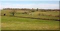
1
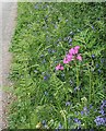
Roadside Verge
It is May and this verge is bright with Bluebells and Red Campion but the bracken stalks are growing fast.
Image: © Tony Atkin
Taken: 13 May 2006
0.09 miles
2
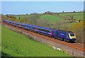
Cornish Main Line
Main line at St Germans.
Image: © Wayland Smith
Taken: 23 Apr 2016
0.10 miles

8
Bag Lane
The twin hedges that accompany the lane between St Germans and Trerulefoot.
Image: © Derek Harper
Taken: 21 Mar 2016
0.13 miles