IMAGES TAKEN NEAR TO
Quay Road, SALTASH, PL12 5LY
Introduction
This page details the photographs taken nearby to Quay Road, PL12 5LY by members of the Geograph project.
The Geograph project started in 2005 with the aim of publishing, organising and preserving representative images for every square kilometre of Great Britain, Ireland and the Isle of Man.

There are currently over 7.5m images from over14,400 individuals and you can help contribute to the project by visiting https://www.geograph.org.uk
Image Map
Images are licensed for reuse under creativecommons.org/licenses/by-sa/2.0
Notes
- Clicking on the map will re-center to the selected point.
- The higher the marker number, the further away the image location is from the centre of the postcode.
Image Listing (95 Images Found)
Images are licensed for reuse under creativecommons.org/licenses/by-sa/2.0
Image
Details
Distance
8
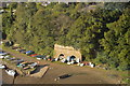
Dinghies stacked up for the winter
By the River Tiddy at the end of Quay Road.
Image: © Kate Jewell
Taken: 8 Feb 2010
0.12 miles
9
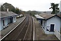
St Germans station
Looking towards Plymouth from the footbridge at the station.On the left was the old station goods yard where you can now stay in an old coach.
Image: © roger geach
Taken: 29 Nov 2008
0.12 miles
10
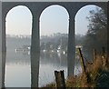
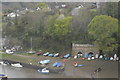
St Germans, Cornwall
This tranquil view looks down the creek and under the rail viaduct to the picturesque little quayside of St Germans.
Image: © John Davey
Taken: 16 Feb 2002
0.12 miles