IMAGES TAKEN NEAR TO
Dolbeare Court, SALTASH, PL12 5FJ
Introduction
This page details the photographs taken nearby to Dolbeare Court, PL12 5FJ by members of the Geograph project.
The Geograph project started in 2005 with the aim of publishing, organising and preserving representative images for every square kilometre of Great Britain, Ireland and the Isle of Man.

There are currently over 7.5m images from over14,400 individuals and you can help contribute to the project by visiting https://www.geograph.org.uk
Image Map
Images are licensed for reuse under creativecommons.org/licenses/by-sa/2.0
Notes
- Clicking on the map will re-center to the selected point.
- The higher the marker number, the further away the image location is from the centre of the postcode.
Image Listing (15 Images Found)
Images are licensed for reuse under creativecommons.org/licenses/by-sa/2.0
Image
Details
Distance
1
Dolbeare Caravan Park, Landrake
The entrance to Dolbeare Caravan Park, Landrake, Cornwall.
Image: © Kevin Hale
Taken: 3 Jun 2006
0.04 miles
2
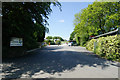
View near Penquite
From a lane T-junction near Higher Penquite, with Pillaton the village in Image and Kit Hill beyond to the right.
Image: © Derek Harper
Taken: 10 Oct 2013
0.09 miles
3
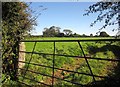
Field at Penquite
From beside the lane through Penquite. Across the field is Tri Acre Kennels.
Image: © Derek Harper
Taken: 10 Oct 2013
0.11 miles
4
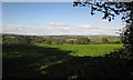
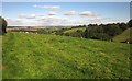
Sheep west of Dolbeare Park
Looking to the right from the same spot as Image] to the head of the valley below Tartendown Cross.
Image: © Derek Harper
Taken: 10 Oct 2013
0.13 miles
5
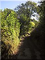
Green lane at Steplake
Shown on the map I was carrying as a yellow, therefore presumably motorable road, but now appearing as a route with public access and obviously abandoned by the roadmender.
Image: © Derek Harper
Taken: 10 Oct 2013
0.13 miles
6
No Such Place, Penquite
Rather contradicting itself by existing by the laneside at Penquite.
Image: © Derek Harper
Taken: 10 Oct 2013
0.14 miles
7
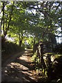
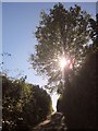
Lane at Penquite
From close to Image], looking along the walled lane as it climbs towards Dolbeare Park.
Image: © Derek Harper
Taken: 10 Oct 2013
0.14 miles
8
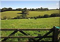
Sheep west of Dolbeare Park
From the lane shown in Image The caravan site at Dolbeare Park is hidden by the trees at the top of the slope. The valley is one shown lower down in Image
Image: © Derek Harper
Taken: 10 Oct 2013
0.14 miles
9
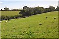
Sheep pasture west of Dolbeare Park
Looking to the left from the same gate as Image] and Image The field adjoins the lane shown in Image
Image: © Derek Harper
Taken: 10 Oct 2013
0.16 miles
10
Lane near North Park
Into the sun as the narrow lane climbs from North Park to Tartendown Cross.
Image: © Derek Harper
Taken: 10 Oct 2013
0.18 miles