IMAGES TAKEN NEAR TO
Tideford Road, SALTASH, PL12 5DS
Introduction
This page details the photographs taken nearby to Tideford Road, PL12 5DS by members of the Geograph project.
The Geograph project started in 2005 with the aim of publishing, organising and preserving representative images for every square kilometre of Great Britain, Ireland and the Isle of Man.

There are currently over 7.5m images from over14,400 individuals and you can help contribute to the project by visiting https://www.geograph.org.uk
Image Map (Loading...)


Getting Data...Please wait
Leaflet Map data © OpenStreetMap
Images are licensed for reuse under creativecommons.org/licenses/by-sa/2.0
Notes
- Clicking on the map will re-center to the selected point.
- The higher the marker number, the further away the image location is from the centre of the postcode.
Image Listing (42 Images Found)
Images are licensed for reuse under creativecommons.org/licenses/by-sa/2.0
Image
Details
Distance
1
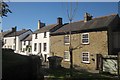
Tideford Road, Landrake
A clearer view than Image] of the listed cottages on the lane to the A38 westwards: on the right, the unrendered Salmon Cottages, 1849 http://list.english-heritage.org.uk/resultsingle.aspx?uid=1329153&searchtype=mapsearch ; to their left the rendered Penwyn http://list.english-heritage.org.uk/resultsingle.aspx?uid=1158601&searchtype=mapsearch , with steps up to the front door, and the older Rose Cottage beyond, set back a little http://list.english-heritage.org.uk/resultsingle.aspx?uid=1140566&searchtype=mapsearch .
Image: © Derek Harper
Taken: 10 Oct 2013
0.01 miles
2
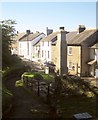
Tideford Road, Landrake
Seen from a path in the churchyard that passes the war memorial. Behind this are the rubble Salmon Cottages, 1849 http://list.english-heritage.org.uk/resultsingle.aspx?uid=1329153&searchtype=mapsearch ; to their left are the rendered Penwyn http://list.english-heritage.org.uk/resultsingle.aspx?uid=1158601&searchtype=mapsearch , with steps up to the front door, and the older Rose Cottage http://list.english-heritage.org.uk/resultsingle.aspx?uid=1140566&searchtype=mapsearch .
Image: © Derek Harper
Taken: 10 Oct 2013
0.01 miles
4
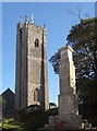
Church tower and war memorial, Landrake
A view from Tideford Road of the tower of Image] and the war memorial http://www.roll-of-honour.com/Cornwall/Landrake.html http://www.ukniwm.org.uk/server/show/conMemorial.41413/fromUkniwmSearch/1 .
Image: © Derek Harper
Taken: 10 Oct 2013
0.02 miles
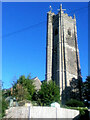
5
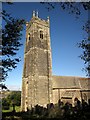
Church of St Michael, Landrake
A grade I listed building http://list.english-heritage.org.uk/resultsingle.aspx?uid=1140553&searchtype=mapsearch "with a tower 100 feet high which can be seen from far away" (Pevsner, 1951).
Image: © Derek Harper
Taken: 10 Oct 2013
0.03 miles
6
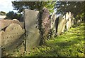
Gravestones, Landrake
In the churchyard of St Michael's church, with lettering highlighted by the autumn sun.
Image: © Derek Harper
Taken: 10 Oct 2013
0.03 miles
7
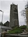
St Michael and All Angel?s Church, Landrake
The building of the 100ft Tower which is in three stages, buttressed on the square and finished with battlements and pinnacles commenced during the late 14th century taking nearly fifty years to complete.
Image: © Richard Rogerson
Taken: 29 Mar 2013
0.04 miles
8
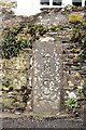
Old Milestone by the former A38 in Landrake
Carved stone post by the UC road (was A38), in parish of LANDRAKE WITH ST ERNEY (CARADON District), Tideford Road, by "Mera", in garden wall, on North side of road. Saltash 'S' stone, erected by the Saltash turnpike trust in the 18th century.
Inscription reads:-
4
M
-
S
Grade II Listed. List Entry Number:1158599
https://historicengland.org.uk/listing/the-list/list-entry/1158599
Milestone Society National ID: CW_SHLK04.
Image: © Ian Thompson
Taken: 1 May 2006
0.04 miles
9
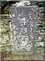
Old Milestone by the former A38 in Landrake
Carved stone post by the UC road (was A38), in parish of LANDRAKE WITH ST ERNEY (CARADON District), Tideford Road, by "Mera", in garden wall, on North side of road. Saltash 'S' stone, erected by the Saltash turnpike trust in the 18th century.
Inscription reads:-
4
M
--
S
Grade II listed.
List Entry Number: 1158599 https://historicengland.org.uk/listing/the-list/list-entry/1158599
Milestone Society National ID: CW_SHLK04.
Image: © Rosy Hanns
Taken: 20 Mar 2019
0.04 miles
10
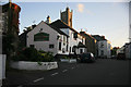
Last of the sun
Just before sunset the church tower catches the last rays of the sun while the Bullers Arms are in shadow. Landrake Village; this was once the main A38 Plymouth road,now bypassed but very busy.
Image: © roger geach
Taken: 14 Aug 2011
0.05 miles