IMAGES TAKEN NEAR TO
Ducky Lane, SALTASH, PL12 5DL
Introduction
This page details the photographs taken nearby to Ducky Lane, PL12 5DL by members of the Geograph project.
The Geograph project started in 2005 with the aim of publishing, organising and preserving representative images for every square kilometre of Great Britain, Ireland and the Isle of Man.

There are currently over 7.5m images from over14,400 individuals and you can help contribute to the project by visiting https://www.geograph.org.uk
Image Map
Images are licensed for reuse under creativecommons.org/licenses/by-sa/2.0
Notes
- Clicking on the map will re-center to the selected point.
- The higher the marker number, the further away the image location is from the centre of the postcode.
Image Listing (38 Images Found)
Images are licensed for reuse under creativecommons.org/licenses/by-sa/2.0
Image
Details
Distance
1
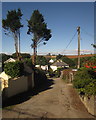
Ducky Lane, Landrake
A narrow village lane seen from School Road. Ducky ... drake ...?
Image: © Derek Harper
Taken: 10 Oct 2013
0.02 miles
2
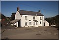
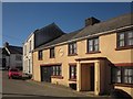
Lowertown Farm Cottage
A cottage on the edge of the village of Landrake, with modern housing beside it. The no entry sign is at the start of the lane shown in Image
Image: © Derek Harper
Taken: 10 Oct 2013
0.07 miles
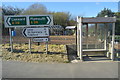
3
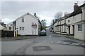
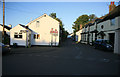
Road junction, Landrake
The junction of Tideford Road and School Road, Landrake, south east Cornwall. The signpost on the left by the yellow Fire Hydrant post is an unusual mix of old and new. The post is cast iron with the word 'Cornwall' cast vertically into it, topped with modern arrow signs. The overhead cables to almost every property give the impression of scratched film at first glance!
Image: © Kevin Hale
Taken: 1 Jan 2006
0.09 miles
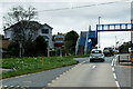
5
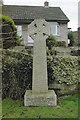
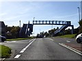
Millennium Cross, Landrake
The Millennium Cross, by the A38 at Landrake, south east Cornwall.
Image: © Kevin Hale
Taken: 1 Jan 2006
0.09 miles
7
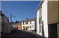
Fore Street, Landrake
Seen from School Road, passing the junction with New Road.
Image: © Derek Harper
Taken: 10 Oct 2013
0.10 miles
9
The Old Smithy, Landrake
Bearing the date 1520 on the facade, though unlisted. This is on Fore Street, close to The Square.
Image: © Derek Harper
Taken: 10 Oct 2013
0.11 miles
10
Landrake last of the sun
The junction of Tideford Road and School Road, Landrake, south east Cornwall. The sun is about to set so the shadows are very long. Most of the picture is in darkness.
Image: © roger geach
Taken: 14 Aug 2011
0.11 miles