IMAGES TAKEN NEAR TO
Ashburgh Parc, SALTASH, PL12 4XZ
Introduction
This page details the photographs taken nearby to Ashburgh Parc, PL12 4XZ by members of the Geograph project.
The Geograph project started in 2005 with the aim of publishing, organising and preserving representative images for every square kilometre of Great Britain, Ireland and the Isle of Man.

There are currently over 7.5m images from over14,400 individuals and you can help contribute to the project by visiting https://www.geograph.org.uk
Image Map
Images are licensed for reuse under creativecommons.org/licenses/by-sa/2.0
Notes
- Clicking on the map will re-center to the selected point.
- The higher the marker number, the further away the image location is from the centre of the postcode.
Image Listing (10 Images Found)
Images are licensed for reuse under creativecommons.org/licenses/by-sa/2.0
Image
Details
Distance
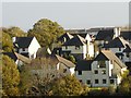
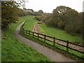
1
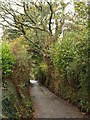
Langerwell Lane
The old lane, now a footpath, conveys a rural image, but on either side are modern housing estates.
Image: © Derek Harper
Taken: 12 Nov 2009
0.06 miles
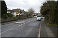
2
Burraton Combe
Footpath 636/35/2 runs down the valley of the Latchbrook Leat. Seen from path 636/33/3.
Image: © Derek Harper
Taken: 12 Nov 2009
0.11 miles
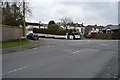
3
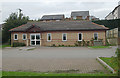
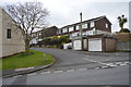
Community Centre, Gallacher Way, Saltash
Community Centre, Gallacher Way, Saltash, built as part of the Latchbrook estate by the developers.
Image: © Kevin Hale
Taken: 17 Oct 2005
0.17 miles