IMAGES TAKEN NEAR TO
Babis Farm Mews, SALTASH, PL12 4SZ
Introduction
This page details the photographs taken nearby to Babis Farm Mews, PL12 4SZ by members of the Geograph project.
The Geograph project started in 2005 with the aim of publishing, organising and preserving representative images for every square kilometre of Great Britain, Ireland and the Isle of Man.

There are currently over 7.5m images from over14,400 individuals and you can help contribute to the project by visiting https://www.geograph.org.uk
Image Map (Loading...)


Getting Data...Please wait
Leaflet Map data © OpenStreetMap
Images are licensed for reuse under creativecommons.org/licenses/by-sa/2.0
Notes
- Clicking on the map will re-center to the selected point.
- The higher the marker number, the further away the image location is from the centre of the postcode.
Image Listing (48 Images Found)
Images are licensed for reuse under creativecommons.org/licenses/by-sa/2.0
Image
Details
Distance
1
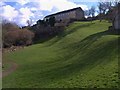
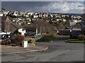
Grass area, Prouse Rise, Saltash
On the slopes of the Coombe valley. The housing ahead is on Babis Farm Way.
Image: © Derek Harper
Taken: 4 Mar 2009
0.02 miles
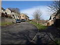
3
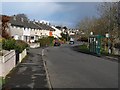
Spencer Gardens, Saltash
A curving road on the housing estate above the Coombe valley.
Image: © Derek Harper
Taken: 4 Mar 2009
0.08 miles
4
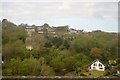
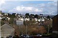
Chichester Crescent, Saltash
Housing drops down the hill towards the valley behind Coombe Viaduct. Across the valley are buildings on Higher Port View, including St Barnabas Hospital.
Image: © Derek Harper
Taken: 4 Mar 2009
0.10 miles
5
Babis Farm Close, Saltash
A cul-de-sac on a housing estate on the steep slopes of a valley above Coombe Creek.
Image: © Derek Harper
Taken: 4 Mar 2009
0.11 miles
6
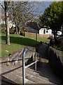
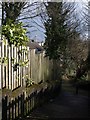
Steps from Spencer Gardens, Saltash
The steps lead down into the steep Coombe valley via Babis Lane. As with Image, there is a glimpse of one of the Tamar bridges.
Image: © Derek Harper
Taken: 4 Mar 2009
0.11 miles
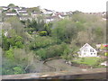
8
Port View, Saltash
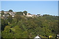
"Port View was laid out as a gated community of villas set in their own grounds and attracted wealthy merchants, businessmen and retired military officers. In addition to the houses the mini estate included ... a Roman Catholic Franciscan Friary converted in the same year from an earlier house called Vinelands. Polsue commented in 1872 that ‘many neat and tasteful villas have been built on the most interesting and commanding sites’." From http://www.historic-cornwall.org.uk/csus/towns/saltash/csus_saltash_report_2005R073.pdf The friary, now apartments called Friary Court is the large building left of centre. The western end of the Tamar road bridge peeps over the hill.
Seen from Chichester Crescent.
Image: © Derek Harper
Taken: 4 Mar 2009
0.11 miles
9
Steps to Babis Lane
Steps from Babis Farm Way drop to join the steep path descending to the Coombe valley. A glimpse of the western pillars of the Tamar Road Bridge.
Image: © Derek Harper
Taken: 4 Mar 2009
0.12 miles