IMAGES TAKEN NEAR TO
Chichester Crescent, SALTASH, PL12 4PJ
Introduction
This page details the photographs taken nearby to Chichester Crescent, PL12 4PJ by members of the Geograph project.
The Geograph project started in 2005 with the aim of publishing, organising and preserving representative images for every square kilometre of Great Britain, Ireland and the Isle of Man.

There are currently over 7.5m images from over14,400 individuals and you can help contribute to the project by visiting https://www.geograph.org.uk
Image Map (Loading...)


Getting Data...Please wait
Leaflet Map data © OpenStreetMap
Images are licensed for reuse under creativecommons.org/licenses/by-sa/2.0
Notes
- Clicking on the map will re-center to the selected point.
- The higher the marker number, the further away the image location is from the centre of the postcode.
Image Listing (36 Images Found)
Images are licensed for reuse under creativecommons.org/licenses/by-sa/2.0
Image
Details
Distance
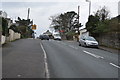
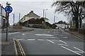
1
Junction of Broad Walk with Chichester Crescent, Saltash
Threatening skies to the north (and the south also, in fact), as Broad Walk meets the point where Beatrice Avenue on the left becomes Chichester Crescent, ahead. Without wishing to be disparaging about it, I would say that the area in the background is the Wearde area of Saltash.
Image: © Derek Harper
Taken: 4 Mar 2009
0.03 miles
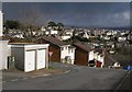
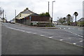
2
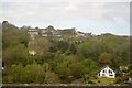
Chichester Crescent, Saltash
Housing drops down the hill towards the valley behind Coombe Viaduct. Across the valley are buildings on Higher Port View, including St Barnabas Hospital.
Image: © Derek Harper
Taken: 4 Mar 2009
0.04 miles
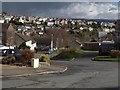
3
View in Saltash
One of the best features of Saltash is the frequency of glimpses of the two Tamar bridges - in this case with Dartmoor as a backdrop. The housing across the playing field is on Lynher Drive, and the junction in the foreground is of a path to the secondary school with Broad Walk.
Image: © Derek Harper
Taken: 4 Mar 2009
0.05 miles
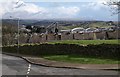
4
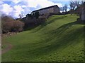
Grass area, Prouse Rise, Saltash
On the slopes of the Coombe valley. The housing ahead is on Babis Farm Way.
Image: © Derek Harper
Taken: 4 Mar 2009
0.12 miles
6
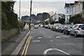
Broad Walk, Saltash
A road on a housing estate near St Stephens. On the right is the junction with Meadway.
Image: © Derek Harper
Taken: 4 Mar 2009
0.15 miles
9
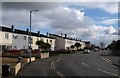
Junction of Long Park Rd and St Stephen's Rd
Image: © N Chadwick
Taken: 14 Feb 2016
0.17 miles