IMAGES TAKEN NEAR TO
Taylor Close, SALTASH, PL12 4LS
Introduction
This page details the photographs taken nearby to Taylor Close, PL12 4LS by members of the Geograph project.
The Geograph project started in 2005 with the aim of publishing, organising and preserving representative images for every square kilometre of Great Britain, Ireland and the Isle of Man.

There are currently over 7.5m images from over14,400 individuals and you can help contribute to the project by visiting https://www.geograph.org.uk
Image Map
Images are licensed for reuse under creativecommons.org/licenses/by-sa/2.0
Notes
- Clicking on the map will re-center to the selected point.
- The higher the marker number, the further away the image location is from the centre of the postcode.
Image Listing (68 Images Found)
Images are licensed for reuse under creativecommons.org/licenses/by-sa/2.0
Image
Details
Distance
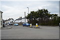
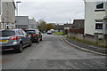
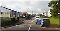
2
Liskeard Road, Saltash
A row of semi-detached houses on the just west of the junction with Callington Road in Burraton.
Image: © Derek Harper
Taken: 12 Nov 2009
0.03 miles
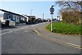
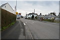
9
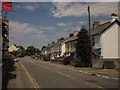
Callington Road, Burraton
The B3271, seen from the junction with Berry Park (right).
Image: © Derek Harper
Taken: 7 Jun 2013
0.05 miles